.mw-parser-output .hidden-begin{box-sizing:border-box;width:100%;padding:5px;border:none;font-size:95%}.mw-parser-output .hidden-title{font-weight:bold;line-height:1.6;text-align:left}.mw-parser-output .hidden-content{text-align:left}You can help expand this article with text translated from the corresponding article in German. (February 2009) Click [show] for important translation instructions.
View a machine-translated version of the German article.
Machine translation, like DeepL or Google Translate, is a useful starting point for translations, but translators must revise errors as necessary and confirm that the translation is accurate, rather than simply copy-pasting machine-translated text into the English Wikipedia.
Do not translate text that appears unreliable or low-quality. If possible, verify the text with references provided in the foreign-language article.
You must provide copyright attribution in the edit summary accompanying your translation by providing an interlanguage link to the source of your translation. A model attribution edit summary is Content in this edit is translated from the existing German Wikipedia article at [[:de:Aichhalden]]; see its history for attribution.
You should also add the template ((Translated|de|Aichhalden)) to the talk page.
For more guidance, see Wikipedia:Translation.
Aichhalden | |
|---|---|
 Coat of arms | |
Location of Aichhalden within Rottweil district 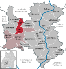 | |
 Aichhalden  Aichhalden | |
| Coordinates: 48°16′N 08°24′E / 48.267°N 8.400°E | |
| Country | Germany |
| State | Baden-Württemberg |
| Admin. region | Freiburg |
| District | Rottweil |
| Government | |
| • Mayor (2017–25) | Michael Lehrer[1] |
| Area | |
| • Total | 25.74 km2 (9.94 sq mi) |
| Elevation | 716 m (2,349 ft) |
| Population (2021-12-31)[2] | |
| • Total | 4,208 |
| • Density | 160/km2 (420/sq mi) |
| Time zone | UTC+01:00 (CET) |
| • Summer (DST) | UTC+02:00 (CEST) |
| Postal codes | 78733 |
| Dialling codes | 07422, 07444, 07836 |
| Vehicle registration | RW |
| Website | www.aichhalden.de |
Aichhalden is a municipality in the district of Rottweil, in Baden-Württemberg, Germany.