This article has multiple issues. Please help improve it or discuss these issues on the talk page. (Learn how and when to remove these template messages)
.mw-parser-output .hidden-begin{box-sizing:border-box;width:100%;padding:5px;border:none;font-size:95%}.mw-parser-output .hidden-title{font-weight:bold;line-height:1.6;text-align:left}.mw-parser-output .hidden-content{text-align:left}@media all and (max-width:500px){.mw-parser-output .hidden-begin{width:auto!important;clear:none!important;float:none!important))You can help expand this article with text translated from the corresponding article in German. (June 2020) Click [show] for important translation instructions.
Machine translation, like DeepL or Google Translate, is a useful starting point for translations, but translators must revise errors as necessary and confirm that the translation is accurate, rather than simply copy-pasting machine-translated text into the English Wikipedia.
Do not translate text that appears unreliable or low-quality. If possible, verify the text with references provided in the foreign-language article.
You must provide copyright attribution in the edit summary accompanying your translation by providing an interlanguage link to the source of your translation. A model attribution edit summary is Content in this edit is translated from the existing German Wikipedia article at [[:de:Landkreis Ammerland]]; see its history for attribution.
You may also add the template ((Translated|de|Landkreis Ammerland)) to the talk page.
For more guidance, see Wikipedia:Translation.
This article needs additional citations for verification. Please help improve this article by adding citations to reliable sources. Unsourced material may be challenged and removed.Find sources: "Ammerland" – news · newspapers · books · scholar · JSTOR (March 2013) (Learn how and when to remove this message)
(Learn how and when to remove this message)
53°15′N 7°55′E / 53.25°N 7.92°E
Ammerland | |
|---|---|
 | |
 Flag  Coat of arms | |
 | |
| Country | Germany |
| State | Lower Saxony |
| Capital | Westerstede |
| Government | |
| • District admin. | Karin Harms |
| Area | |
| • Total | 728 km2 (281 sq mi) |
| Population (31 December 2022)[1] | |
| • Total | 128,253 |
| • Density | 180/km2 (460/sq mi) |
| Time zone | UTC+01:00 (CET) |
| • Summer (DST) | UTC+02:00 (CEST) |
| Vehicle registration | WST |
| Website | ammerland.de |
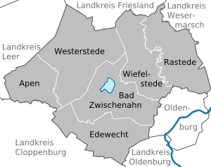
Ammerland is a district in Lower Saxony, Germany. It is bounded by (from the east and clockwise) the city of Oldenburg and the districts of Oldenburg, Cloppenburg, Leer, Friesland and Wesermarsch.