Ampilly-les-Bordes | |
|---|---|
 The road into Ampilly-les-Bordes | |
Location of Ampilly-les-Bordes  | |
 Ampilly-les-Bordes  Ampilly-les-Bordes | |
| Coordinates: 47°38′01″N 4°37′47″E / 47.6336°N 4.6297°E | |
| Country | France |
| Region | Bourgogne-Franche-Comté |
| Department | Côte-d'Or |
| Arrondissement | Montbard |
| Canton | Châtillon-sur-Seine |
| Intercommunality | Pays Châtillonnais |
| Government | |
| • Mayor (2020–2026) | Luc Babouillard[1] |
| Area 1 | 14.48 km2 (5.59 sq mi) |
| Population (2021)[2] | 82 |
| • Density | 5.7/km2 (15/sq mi) |
| Time zone | UTC+01:00 (CET) |
| • Summer (DST) | UTC+02:00 (CEST) |
| INSEE/Postal code | 21011 /21450 |
| Elevation | 350–421 m (1,148–1,381 ft) (avg. 400 m or 1,300 ft) |
| 1 French Land Register data, which excludes lakes, ponds, glaciers > 1 km2 (0.386 sq mi or 247 acres) and river estuaries. | |
Ampilly-les-Bordes (French pronunciation: [ɑ̃piji le bɔʁd]) is a commune in the Côte-d'Or department in the Bourgogne-Franche-Comté region of eastern France.
Geography
[edit]Ampilly-les-Bordes is located some 40 km south by south-east of Chatillon-sur-Seine and 25 km east of Montbard. It can be accessed by highway D971 from Saint-Marc-sur-Seine in the north passing through the commune east of the village and continuing south to Chanceaux. The village can be accessed by road D114 running west from the D971 through the village and continuing west to Etormay. The D114P runs east from the D971 to Quemignerot. The D954 runs from Baigneux-les-Juifs in the south through the southern part of the commune to Quemignerot. Apart from the village there is the hamlet of Ampilly-le-Haut at the intersection of the D971 and D114. The commune consists entirely of farmland except for a few patches of forest.[3]
A small stream rises in the south of the commune and flows south.
Neighbouring communes and villages
[edit]Places adjacent to Ampilly-les-Bordes | ||||||||||||||||
|---|---|---|---|---|---|---|---|---|---|---|---|---|---|---|---|---|
| ||||||||||||||||
Administration
[edit]
List of Successive Mayors[4]
| From | To | Name |
|---|---|---|
| 2001 | 2008 | Odette Parent |
| 2008 | 2026 | Luc Babouillard |
Demography
[edit]The inhabitants of the commune are known as Ampilliens or Ampilliennes in French.[5]
|
| ||||||||||||||||||||||||||||||||||||||||||||||||||||||||||||||||||||||||||||||||||||||||||||||||||||||||||||||||||
| Source: EHESS[6] and INSEE[7] | |||||||||||||||||||||||||||||||||||||||||||||||||||||||||||||||||||||||||||||||||||||||||||||||||||||||||||||||||||


Culture and heritage
[edit]Civil heritage
[edit]The commune has a number of buildings and structures that are registered as historical monuments:
- A Lavoir (Public laundry) at CR 9 (19th century)
 [8]
[8] - A Farmhouse at Rue de la Fontaine (17th century)[9]
- A Coaching Inn at RN 71 (19th century)[10]
- A Lavoir (Public laundry) at Meursauge (19th century)[11]
- A Semi-detached House at La Folie (19th century)[12]
- A Farmhouse at Ampilly-le-Haut (19th century)[13]
- A Lavoir (Public laundry) at Ampilly-le-Haut (19th century)[14]
- A Farmhouse (1835)[15]
- The Town Hall (18th century)[16]
- Houses and Farms (17th-19th century)[17]
Religious heritage
[edit]The commune has several religious buildings and sites that are registered as historical monuments:
- A Wayside Cross at CVO 3 (1680)[18]
- A Wayside Cross at Meursauge (1872)[19]
- The Chapel of Saint-Honoré at Meursauge (15th century).[20] The Chapel contains three items that are registered as historical objects:
- A Wayside Cross at La Folie (1821)[24]
- A Monumental Cross at Ampilly-le-Haut (1875)[25]
- A Monumental Cross (1873)[26]
- A Cemetery Cross (18th century)[27]
- The Tomb of Michel Armand Polycarpe Jacquet (1847)[28]
- The Parish Church of the Assumption (14th century).[29] The church contains many items that are registered as historical objects:
- The Furniture in the Church
 [30]
[30] - A Pail for holy water (18th century)[31]
- A Processional Staff (19th century)[32]
- 2 Reliquaries (18th century)[33]
- A Ciborium (1798)[34]
- A Chalice (1789)[35]
- A Cabinet (19th century)[36]
- A Bas-relief: God the Father (18th century)[37]
- 2 Statues: Saint Christine and Saint Honoré (18th century)[38]
- A Cross: Christ on the Cross (17th century)[39]
- A Canopy (18th century)[40]
- A Confessional (19th century)[41]
- A Pulpit (19th century)[42]
- 2 Statuettes: Angels (18th century)[43]
- An Altar and Tabernacle (18th century)[44]
- The Furniture in the Church
Gallery of Historical Monuments
[edit]-
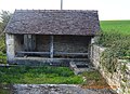 The Lavoir (Public laundry) at CR 9
 -
 A Wayside Cross
 -
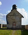 The Chapel of Saint-Honoré
 -
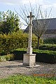 The Monumental Cross at Ampilly-le-Haut
 -
 The Cemetery Cross
 -
 The Tomb of Michel Armand Polycarpe Jacquet
 -
 The Church of the Assumption


See also
[edit]References
[edit]- ^ "Répertoire national des élus: les maires". data.gouv.fr, Plateforme ouverte des données publiques françaises (in French). 2 December 2020.
- ^ "Populations légales 2021" (in French). The National Institute of Statistics and Economic Studies. 28 December 2023.
- ^ a b Google Maps
- ^ List of Mayors of France
- ^ Le nom des habitants du 21 - Côte-d'Or, habitants.fr
- ^ Des villages de Cassini aux communes d'aujourd'hui: Commune data sheet Ampilly-les-Bordes, EHESS (in French).
- ^ Population en historique depuis 1968, INSEE
- ^ Ministry of Culture, Mérimée IA00063603 Lavoir at CR 9 (in French)
- ^ Ministry of Culture, Mérimée IA00063589 Farmhouse at Rue de la Fontaine (in French)
- ^ Ministry of Culture, Mérimée IA00063595 Coaching Inn (in French)
- ^ Ministry of Culture, Mérimée IA00063601 Lavoir at Meursauge (in French)
- ^ Ministry of Culture, Mérimée IA00063598 Semi-detached House at La Folie (in French)
- ^ Ministry of Culture, Mérimée IA00063596 Farmhouse at Ampilly-le-Haut (in French)
- ^ Ministry of Culture, Mérimée IA00063594 Lavoir at Ampilly-le-Haut (in French)
- ^ Ministry of Culture, Mérimée IA00063590 Farmhouse (in French)
- ^ Ministry of Culture, Mérimée IA00063588 Town Hall (in French)
- ^ Ministry of Culture, Mérimée IA00063586 Houses and Farms (in French)
- ^ Ministry of Culture, Mérimée IA00063604 Wayside Cross at CVO 3 (in French)
- ^ Ministry of Culture, Mérimée IA00063602 Wayside Cross at Meursauge (in French)
- ^ Ministry of Culture, Mérimée IA00063600 Chapel of Saint-Honoré at Meursauge (in French)
- ^ Ministry of Culture, Palissy IM21002034 2 Altar Candlesticks (in French)
- ^ Ministry of Culture, Palissy IM21002033 Altar Cross (in French)
- ^ Ministry of Culture, Palissy IM21002032 Statue: Saint John the Baptist (in French)
- ^ Ministry of Culture, Mérimée IA00063599 Wayside Cross at La Folie (in French)
- ^ Ministry of Culture, Mérimée IA00063597 Monumental Cross at Ampilly-le-Haut (in French)
- ^ Ministry of Culture, Mérimée IA00063593 Monumental Cross (in French)
- ^ Ministry of Culture, Mérimée IA00063592 Cemetery Cross (in French)
- ^ Ministry of Culture, Mérimée IA00063591 Tomb of Michel Armand Polycarpe Jacquet (in French)
- ^ Ministry of Culture, Mérimée IA00063587 Parish Church of the Assumption (in French)
- ^ Ministry of Culture, Palissy IM21002031 Furniture in the Church (in French)
- ^ Ministry of Culture, Palissy IM21002030 Pail for holy water (in French)
- ^ Ministry of Culture, Palissy IM21002029 Processional Staff (in French)
- ^ Ministry of Culture, Palissy IM21002028 2 Reliquaries (in French)
- ^ Ministry of Culture, Palissy IM21002027 Ciborium (in French)
- ^ Ministry of Culture, Palissy IM21002026 Chalice (in French)
- ^ Ministry of Culture, Palissy IM21002025 Cabinet (in French)
- ^ Ministry of Culture, Palissy IM21002024 Bas-relief: God the Father (in French)
- ^ Ministry of Culture, Palissy IM21002023 2 Statues: Saint Christine and Saint Honoré (in French)
- ^ Ministry of Culture, Palissy IM21002022 Cross: Christ on the Cross (in French)
- ^ Ministry of Culture, Palissy IM21002021 Canopy (in French)
- ^ Ministry of Culture, Palissy IM21002020 Confessional (in French)
- ^ Ministry of Culture, Palissy IM21002019 Pulpit (in French)
- ^ Ministry of Culture, Palissy IM21002018 2 Statuettes: Angels (in French)
- ^ Ministry of Culture, Palissy IM21002017 Altar and Tabernacle (in French)
External links
[edit]- Ampilly-les-Bordes on the National Geographic Institute website (in French)
- Ampilly-les-Bordes on Géoportail, National Geographic Institute (IGN) website (in French)
- Ampilly-les-Bordes on the 1750 Cassini Map
| International | |
|---|---|
| National | |