| Awenda Provincial Park | |
|---|---|
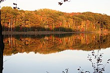
 Georgian Bay panorama at Awenda | |
| Location | Simcoe County, Ontario, Canada |
| Nearest town | Penetanguishene |
| Coordinates | 44°50′29″N 79°59′33″W / 44.84139°N 79.99250°W[1] |
| Area | 2,915 ha (11.25 sq mi) |
| Established | 1975[2] |
| Governing body | Ontario Parks |
| Website | www |
Awenda Provincial Park is a provincial park in Tiny Township, Simcoe County in Central Ontario, Canada, located on a peninsula jutting into Georgian Bay north of Penetanguishene.[1][2][3][4][5][6] The park occupies an area of 2,915 hectares (7,200 acres) and was established in 1975.[2] It is classified as a Natural Environment Park and therefore all land is protected.
Giants Tomb Island, located in southern Georgian Bay approximately 3 kilometres (1.9 mi) from the mainland and the majority of the island is part of the park.[1][3] On the island, no overnight camping is allowed, and no facilities are provided.
Recreational activities at Awenda include camping, swimming, canoeing and hiking.[7] Geological features include the Nipissing Bluff and a kettle lake formed during the retreat of the glaciers at the end of the most recent ice age. The shoreline consists of a series of sand, cobble, and boulder beaches.
Much of this area was logged around the beginning of the 20th century, so most of the mature deciduous forests here are actually second growth. Although dominated by mature deciduous forest, the park has a diversity of habitats, including: bogs, fens, coastal meadow marshes, dunes and pine oak savanna. It supports a rich variety of plant and animal life -including 32 species of amphibians and reptiles.


