Centro Habana | |
|---|---|
 Centro Havana seen from Hotel Habana Libre | |
 Coat of arms | |
 Location of Centro Habana in Havana | |
| Coordinates: 23°08′0″N 82°23′0″W / 23.13333°N 82.38333°W | |
| Country | Cuba |
| Province | Ciudad de La Habana |
| Wards (Consejos Populares) | Cayo Hueso, Colón, Dragones, Los Sitios, Pueblo Nuevo |
| Area | |
| • Total | 4 km2 (2 sq mi) |
| Elevation | 45 m (148 ft) |
| Population (2021)[2] | |
| • Total | 132,451 |
| • Density | 33,000/km2 (86,000/sq mi) |
| Time zone | UTC-5 (EST) |
| Area code | +53-7 |
Centro Habana is one of the 15 municipalities or boroughs (municipios in Spanish) in the city of Havana, Cuba. A chinatown - Barrio Chino - is also located in this district. It is a smaller municipality of Havana, and it has the highest population density.
Centro Habana is divided into five consejos populares (wards): Cayo Hueso, Colón, Dragones, Los Sitios and Pueblo Nuevo.
History
[edit]The infrastructure of the city, built 450 years ago, heavily deteriorated during the 1990s after the collapse of the Cuban-Soviet trade partnership. In 1996, restoration projects were started to improve housing and infrastructure in the Cayo Hueso community.[3]
Centro Habana was established as an administrative division in 1963 and later formally made its own municipio in 1976.[4]
Demographics
[edit]In 2004, the municipality of Centro Habana had a population of 158,151.[2] With a total area of 4 km2 (1.5 sq mi),[1] it has a population density of 39,537.8 inhabitants per square kilometre (102,402/sq mi).
See also
[edit]References
[edit]- ^ a b Statoids (July 2003). "Municipios of Cuba". Retrieved 2007-10-06.
- ^ a b Atenas.cu (2004). "2004 Population trends, by Province and Municipality" (in Spanish). Archived from the original on 2006-07-14. Retrieved 2007-10-06.
- ^ Restoration Project Archived March 11, 2007, at the Wayback Machine - Canada International Development Research Centre
- ^ Bartolomé Bárguez, Carlos (2006). "Ciudad de La Habana. La identidad de la provincia y sus municipios" (in Spanish).
Gallery
[edit]-
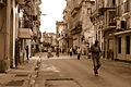 Calle Lazaro (close to the Malecon).
 -
 Calle Lealtad.
 -
 Calle Hospital.
 -
![Church of the Sacred Heart of Jesus [es] in Calle Reina.](https://upload.wikimedia.org/wikipedia/commons/thumb/2/26/Iglesia_del_Sagrado_Corazon_-_Centro_Habana.JPG/90px-Iglesia_del_Sagrado_Corazon_-_Centro_Habana.JPG) Church of the Sacred Heart of Jesus in Calle Reina.
Church of the Sacred Heart of Jesus in Calle Reina. -
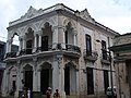 Casona of Calle Reina.
 -
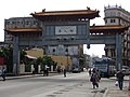 Main Gate to Chinatown.


![Church of the Sacred Heart of Jesus [es] in Calle Reina.](/en/File:Iglesia_del_Sagrado_Corazon_-_Centro_Habana.JPG)


External links
[edit] Media related to Centro Habana at Wikimedia Commons
- Centro Habana guia turistica - touristic guide (Spanish)
- Hotels in Centro Habana, Cuba Travel and tourism.
Places adjacent to Centro Habana | ||||||||||||||||
|---|---|---|---|---|---|---|---|---|---|---|---|---|---|---|---|---|
| ||||||||||||||||
| Arroyo Naranjo |
| |
|---|---|---|
| Boyeros |
| |
| Centro Habana |
| |
| Cerro |
| |
| Cotorro |
| |
| Diez de Octubre | ||
| Guanabacoa |
| |
| La Habana del Este |
| |
| La Habana Vieja |
| |
| La Lisa |
| |
| Marianao |
| |
| Playa |
| |
| Plaza de la Revolución |
| |
| Regla |
| |
| San Miguel del Padrón |
| |