-
 Summit
 -
 Sunrise at the summit
 -
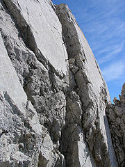 Crux on the upper part of the Gamsängersteig
 -
 The Babenstuber Hut just below the summit of the Ellmauer Halt
 -
 View towards the Inn valley from Ellmauer Halt shortly before sunrise
| Ellmauer Halt | |
|---|---|
 The Ellmauer Halt from the south | |
| Highest point | |
| Elevation | 2,344 m (7,690 ft)[1] |
| Prominence | 1,552 m (5,092 ft)[1] |
| Isolation | 23.1 km (14.4 mi) |
| Listing | Ultra |
| Coordinates | 47°33′44″N 12°18′11″E / 47.56222°N 12.30306°E[1] |
| Geography | |
 Ellmauer Halt Location in the Alps | |
| Location | Tyrol, Austria |
| Parent range | Kaiser Mountains |
| Geology | |
| Age of rock | Triassic |
| Mountain type | Wetterstein limestone[2] |
| Climbing | |
| First ascent | 29 June 1869 by K. Hoffmann and J. Schlechter |
| Easiest route | Gamsängersteig from the south (moderate climb) |
The Ellmauer Halt (2,344 m) is the highest peak in the mountain massif of the Wilder Kaiser in the Kaiser range (Northern Limestone Alps) in the Austrian state of Tyrol. To the east is the summit of the Kapuzenturm, a striking and isolated rock pinnacle. In 1883 the first summit cross was erected on the mountain top.
The base camp for climbing tours on this mountain is the Grutten Hut mountain hut on its southern flank, at a height of 1,620 m. There is also the unoccupied, tiny Babenstuber Hut, immediately below the summit. This shelter and emergency refuge has stood on the Ellmauer Halt since 1891, but is not weatherproof. In any case the peak should only be climbed in good weather with dry conditions by experienced climbers with secure footwear, no fear of heights and climbing agility. Due to the popularity of the Ellmauer Halt there is a high risk of falling rocks, especially on the normal path, the Gamsängersteig. A helmet and even a Klettersteig set are therefore recommended.


