Original file (3,333 × 2,365 pixels, file size: 611 KB, MIME type: image/png)
Summary[edit]
| Description |
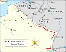
Map pnf version /"Maginot Line" (military defensive line) in France. Disclaimer: The exact location of the forts and lines may differ from reality to a slight extent. |
|---|---|
| Source |
File:Maginot Line ln-en.jpg |
| Date |
15:28, 24 October 2011 (UTC) |
| Author |
Made by Niels Bosboom. |
| Permission (Reusing this file) |
See below. |
| Other versions | SVG version available  |
Licensing[edit]
| This work is licensed under the Creative Commons Attribution-ShareAlike 3.0 License. |
 | This file is a candidate to be copied to Wikimedia Commons.
Any user may perform this transfer; refer to Wikipedia:Moving files to Commons for details. If this file has problems with attribution, copyright, or is otherwise ineligible for Commons, then remove this tag and DO NOT transfer it; repeat violators may be blocked from editing. Other Instructions
| ||
| |||
| This media file is either in the public domain or published under a free license, and contains no inbound file links. If this media file is useful, then it should be transferred to the Wikimedia Commons. If this media is not useful, then please propose it for deletion or list it at files for discussion. |

