Rhondda_Map.JPG(769 × 556 pixels, file size: 44 KB, MIME type: image/jpeg)
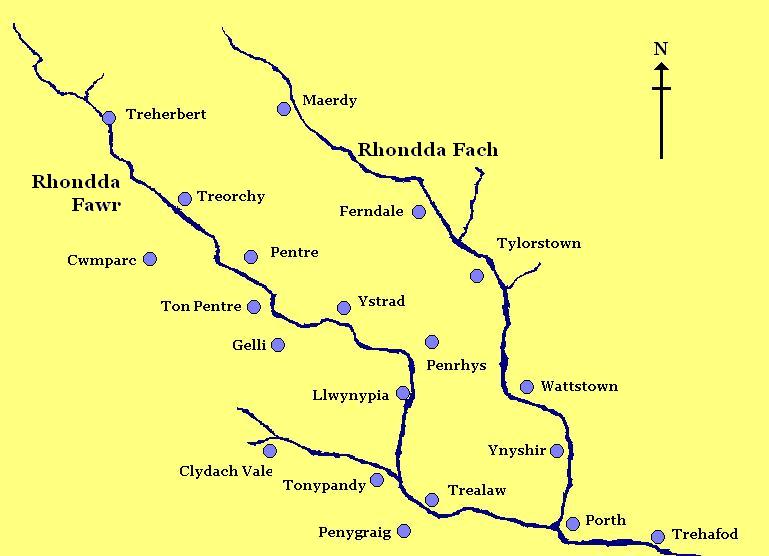
Summary[edit]

File information
Description

A homemade rough map of the Rhondda Valley

Source

I created this work entirely by myself.

Date

10 August 2008

Author

FruitMonkey (talk)

Permission
(Reusing this file)

See below.


Licensing:[edit]

File history

Click on a date/time to view the file as it appeared at that time.

Date/TimeThumbnailDimensionsUserComment
current06:37, 26 February 2009Thumbnail for version as of 06:37, 26 February 2009769 × 556 (44 KB)FruitMonkey (talk | contribs)Reverted to version as of 06:36, 26 February 2009
06:37, 26 February 2009Thumbnail for version as of 06:37, 26 February 2009769 × 556 (41 KB)FruitMonkey (talk | contribs)Reverted to version as of 18:30, 10 August 2008
06:36, 26 February 2009Thumbnail for version as of 06:36, 26 February 2009769 × 556 (44 KB)FruitMonkey (talk | contribs)
06:35, 26 February 2009Thumbnail for version as of 06:35, 26 February 2009769 × 556 (44 KB)FruitMonkey (talk | contribs)Added the names of the two valleys to the map to aid in identification.
18:30, 10 August 2008Thumbnail for version as of 18:30, 10 August 2008769 × 556 (41 KB)FruitMonkey (talk | contribs)((Information |Description= A homemade rough map of the Rhondda Valley |Source=I created this work entirely by myself. |Date=10 August 2008 |Author=~~~ |other_versions= ))

File usage

The following pages on the English Wikipedia use this file (pages on other projects are not listed):

Metadata

This file contains additional information, probably added from the digital camera or scanner used to create or digitize it.

If the file has been modified from its original state, some details may not fully reflect the modified file.

Retrieved from "https://en.wikipedia.org/w/index.php?title=File:Rhondda_Map.JPG&oldid=483246370"