This article has multiple issues. Please help improve it or discuss these issues on the talk page. (Learn how and when to remove these template messages) This article relies largely or entirely on a single source. Relevant discussion may be found on the talk page. Please help improve this article by introducing citations to additional sources.Find sources: "Horvat Uza" – news · newspapers · books · scholar · JSTOR (August 2018) .mw-parser-output .hidden-begin{box-sizing:border-box;width:100%;padding:5px;border:none;font-size:95%}.mw-parser-output .hidden-title{font-weight:bold;line-height:1.6;text-align:left}.mw-parser-output .hidden-content{text-align:left}You can help expand this article with text translated from the corresponding article in Hebrew. (August 2018) Click [show] for important translation instructions. Machine translation, like DeepL or Google Translate, is a useful starting point for translations, but translators must revise errors as necessary and confirm that the translation is accurate, rather than simply copy-pasting machine-translated text into the English Wikipedia. Do not translate text that appears unreliable or low-quality. If possible, verify the text with references provided in the foreign-language article. You must provide copyright attribution in the edit summary accompanying your translation by providing an interlanguage link to the source of your translation. A model attribution edit summary is Content in this edit is translated from the existing Hebrew Wikipedia article at [[:he:חורבת עוזה]]; see its history for attribution. You should also add the template ((Translated|he|חורבת עוזה)) to the talk page. For more guidance, see Wikipedia:Translation. (Learn how and when to remove this template message)
Horvat Uza
חורבת עוזה
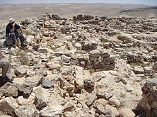
Hurvat Uzza, overlooking Kina River at Arad Valley, Israel.
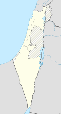
Horvat Uza is located in Israel
Horvat Uza
Shown within Israel
LocationIsrael Southern District, Israel
RegionNegev
Coordinates31°12′33″N 35°09′56″E / 31.20917°N 35.16556°E / 31.20917; 35.16556
TypeFortress
History
PeriodsIron Age
CulturesJudahites

Horvat Uza (Hebrew: חורבת עוזה) is an archaeological site located in the northeast of the Negev desert in Israel. The site is located in the east of the Arad Valley and overlooks Nahal Qinah (Qinah Valley). In ancient times, forts were established there to control the wadi road, linking Judea to Arabah and the territory of Edom. It was mentioned as Qina by Josephus in book 15 of his Antiquities.[1]

Several inscribed potsherds with inscriptions in Hebrew, dated to the 7th-century BCE, were found in Horvat Uza.
Archaeology

The site was first excavated in the 1950s by Nahman Avigad. The excavations revealed that the site was inhabited from the Iron Age II (9th-6th centuries BCE) until the Byzantine period (4th-7th centuries CE). The site was abandoned in the 7th century CE, possibly due to the destruction of the Kingdom of Judah by the Babylonians.[2]

The most notable finds from the site are a number of inscribed potsherds with inscriptions in Hebrew. The inscriptions date to the 7th century BCE and mention the name of the site, “Uza”. The inscriptions also mention the names of several people, including a man named “Ahaz” and a woman named “Ataliah”.

References

  1. ^ Mittmann, Siegfried (2006). "Die Hellenistische Mauerinschrift von Gadara (Umm Qēs) und die Seleukidisch Dynastische Toponymie Palästinas". Journal of Northwest Semitic Languages (in German). Department of Ancient Studies: Stellenbosch University. 32 (2): 32. ISSN 0259-0131.
  2. ^ "The Excavations of Khirbet er-Rasm, Israel: The changing faces of the countryside 9781407307428, 9781407337357". dokumen.pub. Retrieved 2023-08-04.