Kalisz Pomorski | |
|---|---|
.jpg) Our Lady Queen of Poland church | |
 Flag  Coat of arms | |
 Kalisz Pomorski | |
| Coordinates: 53°17′N 15°54′E / 53.283°N 15.900°E | |
| Country | |
| Voivodeship | West Pomeranian |
| County | Drawsko |
| Gmina | Kalisz Pomorski |
| Area | |
| • Total | 11.89 km2 (4.59 sq mi) |
| Population (2006) | |
| • Total | 3,989 |
| • Density | 340/km2 (870/sq mi) |
| Time zone | UTC+1 (CET) |
| • Summer (DST) | UTC+2 (CEST) |
| Postal code | 78-540 |
| Website | http://www.kaliszpom.pl |
Kalisz Pomorski [ˈkalʲiʂ pɔˈmɔrskʲi] (Latin: Nova Calisia; German: Kallies) is a small town in Drawsko County in West Pomeranian Voivodeship in northwestern Poland with about 4,500 inhabitants.
History
[edit]In the 8th century a Slavic gród existed in present-day Kalisz Pomorski.[1] In the Middle Ages it was part of Poland, located in northern Greater Poland. The town's name derives from the city of Kalisz in southern Greater Poland.[1] In order to develop this sparsely populated area, duke Przemysł I brought settlers from Kalisz to the settlement, which was newly named in Latin Nova Calisia (meaning New Kalisz).[1]
It was part of the Kingdom of Prussia from the 18th century and between 1871 and 1945 it was part of Germany. During World War II, in 1944–1945, the Germans operated a subcamp of the Ravensbrück concentration camp in the town, in which they imprisoned around 500–1,000 people at a time.[2] After the defeat of Nazi Germany in World War II, the town became part of Poland again.
Gallery
[edit]-
 Młyńskie Lake
 -
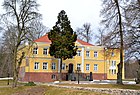 Palace in Kalisz Pomorski
 -
 High school
 -
 Forest office building
_Lake_in_Kalisz_Pomorski.jpg)
.jpg)


Notable residents
[edit]- Paul Sydow (1851 – 1925), German mycologist and lichenologist
International relations
[edit]Twin towns — Sister cities
[edit]Kalisz Pomorski is twinned with:
References
[edit]- ^ a b c "Historia miasta, Miasto i gmina Kalisz Pomorski" (in Polish). Retrieved July 14, 2019.
- ^ Der Ort des Terrors: Geschichte der nationalsozialistischen Konzentrationslager, Vol. IV, 2006, p. 559 (in German)
External links
[edit]| Town and seat | | |
|---|---|---|
| Villages | ||
Geography of Pomerania | |||||
|---|---|---|---|---|---|
| Regions |
| ||||
| Administration | |||||
| Cities and towns |
| ||||
| Inhabited islands | |||||
| Peninsulae and headlands | |||||
| Rivers | |||||
| Lakes | |||||
| Bays, lagoons | |||||
| National parks | |||||
| International | |
|---|---|
| National | |