.mw-parser-output .hidden-begin{box-sizing:border-box;width:100%;padding:5px;border:none;font-size:95%}.mw-parser-output .hidden-title{font-weight:bold;line-height:1.6;text-align:left}.mw-parser-output .hidden-content{text-align:left}@media all and (max-width:500px){.mw-parser-output .hidden-begin{width:auto!important;clear:none!important;float:none!important))You can help expand this article with text translated from the corresponding article in German. (February 2009) Click [show] for important translation instructions.
View a machine-translated version of the German article.
Machine translation, like DeepL or Google Translate, is a useful starting point for translations, but translators must revise errors as necessary and confirm that the translation is accurate, rather than simply copy-pasting machine-translated text into the English Wikipedia.
Consider adding a topic to this template: there are already 9,128 articles in the main category, and specifying|topic= will aid in categorization.
Do not translate text that appears unreliable or low-quality. If possible, verify the text with references provided in the foreign-language article.
You must provide copyright attribution in the edit summary accompanying your translation by providing an interlanguage link to the source of your translation. A model attribution edit summary is Content in this edit is translated from the existing German Wikipedia article at [[:de:Laufenburg]]; see its history for attribution.
You may also add the template ((Translated|de|Laufenburg)) to the talk page.
For more guidance, see Wikipedia:Translation.
This article needs additional citations for verification. Please help improve this article by adding citations to reliable sources. Unsourced material may be challenged and removed.Find sources: "Laufenburg, Germany" – news · newspapers · books · scholar · JSTOR (December 2022) (Learn how and when to remove this message)
Laufenburg | |
|---|---|
_auf_Laufenburg_(Deutschland).jpg) View from CH-Laufenburg to D-Laufenburg. | |
 Coat of arms | |
Location of Laufenburg within Waldshut district 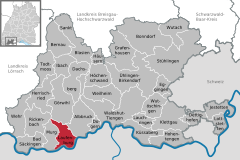 | |
 Laufenburg  Laufenburg | |
| Coordinates: 47°33′56″N 08°03′53″E / 47.56556°N 8.06472°E | |
| Country | Germany |
| State | Baden-Württemberg |
| Admin. region | Freiburg |
| District | Waldshut |
| Subdivisions | 8 Stadtteile |
| Government | |
| • Mayor (2016–24) | Ulrich Krieger[1] |
| Area | |
| • Total | 23.58 km2 (9.10 sq mi) |
| Elevation | 337 m (1,106 ft) |
| Population (2022-12-31)[2] | |
| • Total | 9,136 |
| • Density | 390/km2 (1,000/sq mi) |
| Time zone | UTC+01:00 (CET) |
| • Summer (DST) | UTC+02:00 (CEST) |
| Postal codes | 79725 |
| Dialling codes | 07763, 07753 |
| Vehicle registration | WT |
| Website | www.laufenburg.de |
Laufenburg is a town in Baden-Württemberg, Germany, part of the Waldshut district. It has approximately 4300 inhabitants (including 6 outskirts 8300 inhabitants). Laufenburg is separated from a Swiss city with the same name by the river Rhine.
