Leach Airport
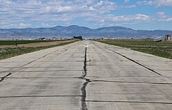
Looking northwest along runway 12/30
Summary
Airport typePublic
OwnerCounty of Saguache
ServesCenter, Colorado
Elevation AMSL7,598 ft / 2,316 m
Coordinates37°47′06″N 106°02′49″W / 37.78500°N 106.04694°W / 37.78500; -106.04694
Map
1V8 is located in Colorado
1V8
1V8
Location of airport in Colorado
Runways
Direction Length Surface
ft m
12/30 7,000 2,134 Asphalt
Statistics (2009)
Aircraft operations1,700
Based aircraft10

Leach Airport (FAA LID: 1V8) is a county-owned, public-use airport in Saguache County, Colorado, United States. It is located four nautical miles (5 mi, 7 km) northeast of the central business district of Center, Colorado,[1] at County Road 53 & County Road C.[2]

Facilities and aircraft

Leach Airport covers an area of 66 acres (27 ha) at an elevation of 7,598 feet (2,316 m) above mean sea level. It has one runway designated 12/30 with an asphalt surface measuring 7,000 by 50 feet (2,134 x 15 m).[1]

For the 12-month period ending September 3, 2009, the airport had 1,700 general aviation aircraft operations, an average of 141 per month. At that time there were 10 aircraft based at this airport: 90% single-engine and 10% ultralight.[1]

Data

Navigation

Runway

Communication

Services

See also

References

  1. ^ a b c d FAA Airport Form 5010 for 1V8 PDF. Federal Aviation Administration. Effective April 5, 2012.
  2. ^ Google.com: Leach Airport Map and Data
  3. ^ a b CDOT Aeronautics: Leach Airport
  • 2007-2008 Colorado Airport Directory, Colorado Division of Aeronautics, CDOT, 5126 Front Range Parkway, Watkins, Colorado, 80137