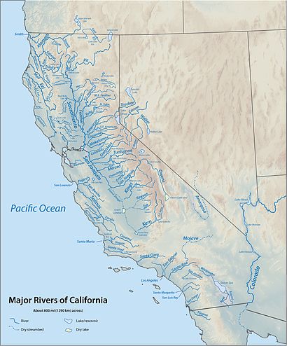
Map of some major California rivers and lakes This is a list of rivers in the U.S. state of California , grouped by region. Major lakes and reservoirs, if applicable, are indicated in italics.
Humboldt Bay
Primary streams entering Humboldt Bay are listed north to south beginning north of the entrance to the bay and continuing in a clockwise direction. Tributaries entering nearest the bay are listed first.[1] [2]
For additional detail on Humboldt Bay streams, see Humboldt Bay: Bay tributaries and sloughs .
North Coast (south of Humboldt Bay)
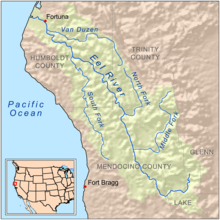
Eel River watershed map Russian River near Duncan's Mills Rivers and streams between Humboldt Bay and the Golden Gate that empty into the Pacific Ocean (arranged north to south; tributaries with those entering nearest the sea first):
For details of the Sonoma and Marin coasts, see List of watercourses in the San Francisco Bay Area .
San Francisco Bay
Streams that empty into San Francisco Bay or its tributary bays (arranged clockwise, starting at the north side of the Golden Gate ; tributaries are listed from those entering nearest the bays to farthest). The Central Valley watershed feeding into Suisun Bay via the Sacramento–San Joaquin Delta is excluded; see the following section for the Sacramento and San Joaquin river systems.
For additional detail on Bay Area creeks, see List of watercourses in the San Francisco Bay Area .
San Pablo Bay (north of Carquinez Strait)
Suisun Bay
Clockwise
San Pablo Bay (south of Carquinez Strait) and San Francisco Bay
For additional detail on Bay Area creeks, see List of watercourses in the San Francisco Bay Area .
Sacramento–San Joaquin River Delta
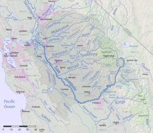
The Sacramento and San Joaquin River systems drain the western slope of the Sierra Nevada and most of the Central Valley, forming the Sacramento–San Joaquin River Delta before emptying into Suisun Bay; together, they are the largest river system in California.
Sacramento River
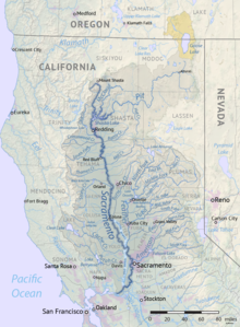
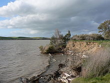
Map of Sacramento River Sacramento River near the mouth Cache Creek , in the Coast Ranges
Yolo Bypass
Yolo Bypass location
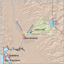
American River
American River drainage basin
Feather River
Feather River drainage basin Headwaters of the Feather River
Yuba River
Yuba River drainage basin
Pit River
Pit River drainage basin Pit River
McCloud River
Nosoni Creek
Chatterdown Creek
Squaw Valley Creek
Claiborne Creek
Hawkins Creek
Star City Creek
Angel Creek
Mud Creek
Ash Creek
Squaw Creek
Salt Creek
North Fork Squaw Creek
Potem Creek Roaring Creek
Iron Canyon Creek
Kosk Creek
Nelson Creek
Rock Creek
Clark Creek
Burney Creek Hat Creek
Fall River
Beaver Creek
Horse Creek
Ash Creek
Willow Creek
Dutch Flat Creek Taylor Creek
Turner Creek
Toms Creek
Clover Swale Creek
Canyon Creek
Rattlesnake Creek
North Fork Pit River
Pine Creek
Parker Creek
Thoms Creek
Joseph Creek
Goose Lake South Fork Pit River
Fitzhugh Creek
Dry Creek
Cedar Creek
Mill Creek
East Creek
San Joaquin River
San Joaquin River map The San Joaquin River
Mokelumne River
Mokelumne River drainage basin Note: In the Delta the Mokelumne River divides into two short branches, also called the "North Fork" and "South Fork", which recombine before reaching the San Joaquin River.
Calaveras River
Calaveras River
New Hogan Dam , New Hogan Lake North Fork Calaveras River
Murray Creek
Jesus Maria Creek
Esperanza Creek
South Fork Calaveras River
Calaveritas Creek
San Antonio Creek
San Domingo Creek
Cherokee Creek
Stanislaus River
Stanislaus River drainage basin
Tuolumne River
Tuolumne River drainage basin
Merced River
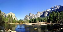
Merced River drainage basin The Merced River in Yosemite Valley
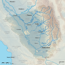
Tulare Basin
Map of the Tulare Lake Basin Usually an endorheic basin, waters in this region all eventually would reach Tulare Lake . This region would overflow into the San Joaquin River during flood years when Tulare Lake overflowed. Streams are listed clockwise around the Tulare Basin, starting at the Kings River:
Kings River jump to tributaries )Sand Creek
Cross Creek
Mill Creek
Elbow Creek
Cottonwood Creek
Lewis Creek
Tule River jump to tributaries )Deer Creek
Pothole Creek
Gordon Creek
Tyler Creek
White River
Coarse Gold Creek
Arrastre Creek
Chalaney Creek Rag Gulch
Five Dog Creek
Willow Springs Creek
Deer Creek
Poso Creek
Little Creek
Rattlesnake Creek
Little Poso Creek
Cedar Creek
Von Hellum Creek
Spear Creek Kern River jump to tributaries )Caliente Creek
Walker Basin Creek
Tehachapi Creek
Indian Creek
Tejon Creek
El Paso Creek
Pastoria Creek
Grapevine Creek
Tecuya Creek
Salt Creek
Pleito Creek
San Emigdio Creek
Los Lobos Creek
Santiago Creek
Bitter Creek
Bitterwater Creek
Sandy Creek
Buena Vista Creek
Salt Creek
Chico Creek
Santos Creek
Media Agua Creek
Bitterwater Creek
Avenal Creek
Baby King Creek
Canoas Creek
Los Gatos Creek
Kings River
Kings River drainage basin Kings River (Divides into the North Fork, South Fork and Clark's Fork distributaries in the San Joaquin Valley, not to be confused with the North and South Forks in the Sierra Nevada headwaters. North Fork connects to the Fresno Slough that drains into the San Joaquin River (during high flows), before turning to the south rejoining with the other distributaries to reform the Kings River and emptying into Tulare Lake .)
Fish Creek
Hughes Creek
Mill Creek Pine Flat Dam , Pine Flat Lake Deer Creek
Zebe Creek
Russian Charlie Creek
Lefever Creek
Billy Creek
Sycamore Creek Big Creek
Sacata Creek
Redoak Creek
Lower Rancheria Creek
Sycamore Springs Creek
North Fork Kings River
Dinkey Creek Basin Creek
Weir Creek
Black Rock Creek
Williams Creek
Mule Creek
Rancheria Creek
Teakettle Creek
Long Meadow Creek
Wishon Dam , Wishon Reservoir Woodchuck Creek
Short Hair Creek
Sharp Creek
Helms Creek
Post Corral Creek
Flemming Creek
Nichols Canyon
Meadow Brook
Fall Creek
Division Lake
Regiment Lake Davis Creek
Verplank Creek
Fox Canyon Creek
Converse Creek
Spring Creek
Cabin Creek
Garlic Meadow Creek
Rough Creek
Ten Mile Creek
Middle Fork Kings River
Deer Canyon Creek
Brush Canyon Creek
Tombstone Creek
Wren Creek
Silver Creek
Crown Creek
Gorge of Despair
Crystal Creek
Blue Canyon Creek
Lost Canyon Creek
Rattlesnake Creek
Alpine Creek
Dog Creek
Kennedy Creek
Dougherty Creek
Horseshoe Creek Goddard Creek
Windy Canyon Creek
Cartridge Creek Rimbaud Creek
Palisade Creek
Cataract Creek
Glacier Creek
Dusy Branch
Helen Lake South Fork Kings River (This is the actual river that flows through Kings Canyon)
Lockwood Creek
Redwood Creek
Windy Gulch
Boulder Creek
Grizzly Creek
Lightning Creek
Deer Cove Creek
Lewis Creek
Sheep Creek
Hotel Creek
Roaring River
Granite Creek
Copper Creek
Avalanche Creek
Bubbs Creek
Sphinx Creek
Charlotte Creek
Cross Creek
North Guard Creek
East Creek Glacier Creek
Gardiner Creek
Woods Creek
Arrow Creek Kid Creek
Kaweah River
Kaweah River drainage basin Kaweah River in the foothills of the SierraKaweah River (Divides into the St. John's River , Mill Creek, Packwood Creek and other distributaries in the San Joaquin Valley. Some of these distributaries eventually rejoin to form Cross Creek, which continues southwest to the Tulare Lake bed.)
Tule River
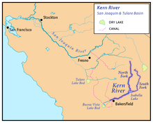
Kern River
Location of the Kern River Kern River
Cottonwood Creek
Lucas Creek
Mill Creek
Erskine Creek
Isabella Dam , Lake Isabella North Fork Kern River
Cannell Creek
Salmon Creek
Tobias Creek
Brush Creek
South Creek
Dry Meadow Creek
Peppermint Creek
Durrwood Creek
Needlerock Creek
Freeman Creek
Little Kern River
Fish Creek
Deep Creek
Deep Creek
Clicks Creek
Sagebrush Gulch
Alpine Creek
Mountaineer Creek
Pecks Canyon Creek
Table Meadow Creek
Soda Springs Creek
Lion Creek
Willow Creek
Tamrack Creek
Rifle Creek
Shotgun Creek
Rattlesnake Creek
Deadman Canyon Creek
Soda Creek
Osa Creek
Hockett Peak Creek
Grouse Canyon Creek
Manzanita Canyon Creek
Ninemile Creek
Cold Meadow Creek
Red Rock Creek
Long Canyon Creek
Long Stringer
Lost Trout Creek
Hells Hole Creek
Angora Creek
Hell For Sure Creek
Leggett Creek
Grasshopper Creek
Little Kern Lake Creek
Rough Creek
Coyote Creek
Golden Trout Creek Laurel Creek
Rattlesnake Creek
Big Arroyo
Willow Creek
Soda Creek
Lost Canyon Creek Funston Creek
Chagoopa Creek
Rock Creek
Red Spur Creek
Whitney Creek
Wallace Creek Kern-Kaweah River
Tyndall Creek
Milestone Creek South Fork Kern River
Kelso Creek
Canebrake Creek Bartolas Creek
Palome Creek
Long Valley Creek
Taylor Creek
Manter Creek
Tibbets Creek
Trout Creek
Fish Creek
Bitter Creek
Lost Creek
Crag Creek
Honeybee Creek
Summit Creek
Cow Canyon Creek
Snake Creek
Soda Creek
Monache Creek
Schaefer Stringer
Strawberry Creek
Long Stringer
Dry Creek
Mulkey Creek
Movie Stringer
Lewis Stringer
Kern Peak Stringer
Central Coast
Rivers that empty into the Pacific Ocean between the Golden Gate and Point Arguello , arranged in order from north to south.
For details of the San Mateo coast, see List of watercourses in the San Francisco Bay Area .
Pajaro River
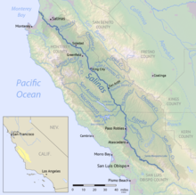
Salinas River
Salinas River drainage basin
Santa Maria River
Santa Maria River drainage basin Santa Maria River
Nipomo Creek
Orcutt Creek
Cuyama River
Sisquoc River
Tepusquet Creek
La Brea Creek
North Fork La Brea Creek
South Fork La Brea Creek
Manzana Creek
Water Canyon
Abel Canyon
South Fork Sisquoc River
Santa Ynez River
Santa Ynez River drainage basin
South Coast
Rivers that empty into the Pacific Ocean southeast of Point Arguello, arranged from north to south:
Santa Clara River
Santa Clara River drainage basin Santa Clara River
Santa Paula Creek
Boulder Creek
Sespe Creek
Little Sespe Creek
Tar Creek
West Fork Sespe Creek
Alder Creek
Park Creek
Timber Creek
Trout Creek
Piedra Blanca Creek
Rose Valley Creek
Rock Creek
Potrero John Creek
Munson Creek
Cherry Creek
Adobe Creek
Abadi Creek Hopper Canyon Creek
Piru Creek
Santa Felicia Dam, Lake Piru Devil Canyon
Canton Canyon
Agua Blanca Creek
Fish Creek
Pyramid Dam , Pyramid Lake Gorman Creek
Buck Creek
Snowy Creek
Smith Fork
Dry Creek
Lockwood Creek
Mutau Creek
Alamo Creek
Little Mutau Creek
Sheep Creek
Cedar Creek Castaic Creek
Bouquet Canyon
South Fork Santa Clara River
Placerita Creek
Newhall Creek
Mint Canyon
Agua Dulce Canyon
Mill Canyon
Acton Canyon
Aliso Canyon
Kentucky Springs Canyon
Ventura River
Ventura River
Manuel Canyon
Cañada Larga
Cañada de Alisos
Coyote Creek
Lake Casitas
Laguna Creek
Willow Creek
Santa Ana Creek
Poplin Creek Deep Cat Lake
East Fork Coyote Creek
West Fork Coyote Creek Matilija Creek
Rattlesnake Creek
Lime Creek
Murietta Creek
Middle Fork Matilija Creek
Upper North Fork Matilija Creek North Fork Matilija Creek (This and Matilija Creek form the Ventura River's headwaters.)
Los Angeles River
San Gabriel River
Santa Ana River
Santa Margarita River
Santa Margarita River
Newton Canyon
Pueblitos Canyon
Wood Canyon
DeLuz Creek
Sandia Creek
Rainbow Creek
Temecula Creek
Pechanga Creek
Vail Lake Dam, Vail Lake
Long Canyon
Cottonwood Creek
Tule Creek
Chihuahua Creek
Rattlesnake Creek
Kohler Canyon Murrieta Creek
Empire Creek
Santa Gertrudis Creek
Tucalota Creek
Long Valley Creek
Warm Springs Creek
Kalmia Creek
Miller Canyon Creek
Cole Canyon Creek
Vail Canyon Creek
Bundy Canyon
San Luis Rey River
San Dieguito River
San Dieguito River
Santa Maria Creek (San Diego)
Santa Ysabel Creek
Temescal Creek (San Diego)
San Diego River
San Diego Bay
Tributaries entering San Diego Bay are arranged from North to South:
Gulf of California
Rivers that empty into the Gulf of California :
Carrizo Plain
The Carrizo Plain is a large enclosed valley near the Central Coast which drains into Soda Lake .
Salton Sea
Rivers that empty into the Salton Sea :
Salt Creek
Dos Palmas Creek
Red Canyon Wash Box Canyon Wash
Whitewater River
North Fork Whitewater River
Middle Fork Whitewater River
South Fork Whitewater River
San Gorgonio River
Portrero Creek
Smith Creek
Hathaway Creek
Twin Pines Creek
One Horse Creek
Snow Creek
West Fork Snow Creek
East Fork Snow Creek
Falls Creek Garnet Wash
Mission Creek
North Fork Mission Creek
South Form Mission Creek
West Fork Mission Creek Morongo Wash
Dry Morongo Wash
Big Morongo Wash
Little Morongo Wash
Chino Canyon Wash Palm Canyon Wash
Cathedral Canyon Wash
Deep Canyon Stormwater Channel
Dead Indian Creek
Grape Vine Creek
Ebbens Creek
Carrizo Creek
Cat Creek
Ramon Creek
Deep Canyon Creek
Thousand Palm Canyon Wash Barton Canyon Wash
Alano Canyon Wash
Sheep Canyon Wash
Travertine Palms Wash
Garner Wash
Wonderstone Wash
Gravel Wash
Big Wash
Grave Wash
Coral Wash
Palm Wash
Anza Ditch
Arroyo Salada
Tule Wash
San Felipe Creek
New River
Alamo River
Great Basin
Rivers in the Great Basin , arranged roughly north to south:
Honey Lake drainage basin Susan River
Willow Creek
Petes Creek
Balls Canyon
Snowstorm Creek
Secret Creek
Piute Creek
Willard Creek Skedaddle Creek
Long Valley Creek
Baxter Creek Pyramid Lake drainage basin Carson Sink drainage basin
Mono Lake
Rivers draining into saline and endorheic Mono Lake in eastern California, from north and proceeding counterclockwise:
Cottonwood Creek
Rancheria Gulch
Wilson Creek
Mill Creek
Deer Creek
South Fork Mill Creek
Dechambeau Creek
Lee Vining Creek
Beartrack Creek
Gibbs Canyon Creek
Warren Fork
Mine Creek
Saddlebag Creek Rush Creek
Walker Creek
Parker Creek
Alger Creek Reversed Creek
Crest Creek Dry Creek Owens Lake drainage basin Streams terminating in the Badwater Basin in Death Valley National Park .
Salt Creek
Furnace Creek Wash
Emigrant Wash
Death Valley Wash
Amargosa River
Wingate Wash
Salt Creek (may carry overflow from the Mojave River basin in extremely wet years)Rock Valley Wash
Fortymile Wash Streams terminating in various dry lakes in the Antelope Valley and Fremont Valley (Koehn Lake , Rosamond Lake , Rogers Dry Lake and others), draining from the southeastern Tehachapi Mountains and northern San Gabriel Mountains , listed counterclockwise starting from north:
Cottonwood Creek
Cache Creek
Oak Creek
Cottonwood Creek
Pescado Creek
Los Alamos Creek
Amargosa Creek
Anaverde Creek
Little Rock Creek
South Fork Little Rock Creek Big Rock Creek
Pallett Creek
Sandrock Creek
South Fork Big Rock Creek
Mescal Creek
Le Montaine Creek
Soda Lake (Mojave River drainage)
Mojave River drainage basin
^ Klamath Resource Information System (KRIS), KRIS Humboldt Bay , URL retrieved November 11, 2007
^ Humboldt Bay Harbor District, Wetlands, Streams, Riparian Areas, and Watershed Areas , URL retrieved November 12, 2007 Archived November 28, 2007, at the Wayback Machine
Rivers of the United States
