City of Tulare | |
|---|---|
 Location in Tulare County and the state of California | |
| Country | United States |
| State | California |
| County | Tulare |
| Government | |
| • Mayor | Craig Vejvoda |
| • City Council | David Macedo Mark Watte Richard Ortega Wayne Ross |
| • City Manager | Darrel Pyle |
| • Finance Director / Treasurer | Darlene Thompson |
| • City Clerk | Roxanne Yoder |
| Area | |
| • Total | 16.7 sq mi (43.2 km2) |
| • Land | 16.6 sq mi (43 km2) |
| • Water | 0.1 sq mi (0.2 km2) |
| Elevation | 289 ft (88 m) |
| Population (2009) | |
| • Total | 59,535 |
| • Density | 2,634.4/sq mi (1,018.4/km2) |
| Time zone | UTC-8 (Pacific (PST)) |
| • Summer (DST) | UTC-7 (PDT) |
| ZIP codes | 93274-93275 |
| Area code | 559 |
| FIPS code | 06-80644 |
| GNIS feature ID | 1652803 |
| Website | www.ci.tulare.ca.us |
Tulare (Template:PronEng) is a city in Tulare County, California, United States. The population, as of 2007, is 55,935. Just eight miles (13 km) south of Visalia, it is part of the Census Bureau's designation of the Visalia Metropolitan Area. The city is named for the currently desiccated Tulare Lake, once the largest freshwater lake west of the Great Lakes. The city's mission statement is: "To promote a quality of life making Tulare the most desirable community in which to live, learn, play, work, worship and prosper." [1] The Stockton seaport is only 170 miles away, and the Sacramento port is 207 miles away. The Los Angeles and San Francisco ports are each approximately 200 miles away, via an outstanding freeway system.
Geography
Tulare is located at 36°12′24″N 119°20′33″W / 36.20667°N 119.34250°WInvalid arguments have been passed to the ((#coordinates:)) function (36.206601, -119.342404)Template:GR. Located directly between Fresno and Bakersfield, Tulare is in the heart of the Central Valley.
According to the United States Census Bureau, the city has a total area of 16.7 square miles (43.2 km²), of which, 16.6 square miles (43.0 km²) of it is land and 0.1 square miles (0.2 km²) of it (0.42%) is water.
Demographics
As of the censusTemplate:GR of 2000, there were 43,994 people, 13,543 households, and 10,753 families residing in the city. The population density was 2,648.2 people per square mile (1,022.6/km²). There were 14,253 housing units at an average density of 858.0/sq mi (331.3/km²). The racial makeup of the city was 56.38% White, 5.02% African American, 1.40% Native American, 2.02% Asian, 0.12% Pacific Islander, 29.09% from other races, and 5.96% from two or more races. Hispanic or Latino of any race were 65.59% of the population.
There were 13,543 households out of which 46.3% had children under the age of 18 living with them, 55.9% were married couples living together, 17.1% had a female householder with no husband present, and 20.6% were non-families. 16.7% of all households were made up of individuals and 8.0% had someone living alone who was 65 years of age or older. The average household size was 3.22 and the average family size was 3.57.
In the city the population was spread out with 34.6% under the age of 18, 10.5% from 18 to 24, 28.7% from 25 to 44, 16.8% from 45 to 64, and 9.4% who were 65 years of age or older. The median age was 28 years. For every 100 females there were 94.4 males. For every 100 females age 18 and over, there were 91.0 males.
The median income for a household in the city was $33,637, and the median income for a family was $36,935. Males had a median income of $31,467 versus $23,775 for females. The per capita income for the city was $13,655. About 16.9% of families and 20.7% of the population were below the poverty line, including 27.1% of those under age 18 and 14.0% of those age 65 or over.
History
Tulare was founded in 1872, by the Southern Pacific Railroad. Tulare flourished as the headquarters of the railroad in the area. The name is for a regional lake, where "tule" (or cattails) grew. The town suffered through many difficult challenges, despite burning down and being rebuilt three times in its first fourteen years of existence, it was eventually incorporated in 1888. In 1891, the railroad moved its headquarters to Bakersfield, decimating the community. Although the railroad was gone, the community of Tulare struggled to became an agricultural center for California. Due to the inadequate 10 inch rainfall per year, water resources had to be found. Once the water system evolved, Tulare burgeoned, becoming a center for farming and agriculture. [2]
During WW II, the Tulare temporary detention center for Japanese Americans received its first inmate on April 20, 1942, and the last inmate departed on September 4, 1942. The top population numbered 4978 citizens. In the latter part of 1942, internees were moved to the ten more permanent internment prisons. The temporary sites were largely located on fairgrounds or race tracks in completely public and visible locations. It was an impossibility for the local citizens to claim that they were not aware of the removal and imprisonment of Japanese American citizens. [3]
Politics
In the state legislature Tulare is located in the 18th Senate District, represented by Republican Roy Ashburn, and in the 34th Assembly District, represented by Republican Connie Conway. Federally, Tulare is located in California's 21st congressional district, which has a Cook PVI of R +13[4] and is represented by Republican Devin Nunes.
Controversies
The City of Tulare was recently sued by the Lawyer's Committee for Civil Rights, for neglecting to form individual districts for the election of City Council members. Tulare's population, as of the last census is 55% Hispanic, eligible Hispanic voters are approximately 40% of the city's population, but just one Latino candidate has been elected to the council in at least 20 years, the group said. The 2010 census figures will most likely enhance the number of Hispanic voters.[5]
Fresno developer Bud Long's proposed car racetrack project in West Tulare has split the city council and at least one member, Vice-Mayor Phil Vandegrift, has resigned over the issue. Vandergrift has been sued because of a "conflict-of-interest", regarding the proposed racetrack. [6]The former police chief supports the racetrack project because, he said, "it will move this community by leaps and bounds" in economic growth. Incumbent David Macedo stated, "The project is in the wrong location because it's too big and too close to homes. Furthermore, the city might run short of money trying to build public roads to the track." he said. [7]
Education
The Tulare County Office of Education services 46 Tulare County School Districts with over 93,000 students.[8] Tulare County school districts cover an extensive span, from single school districts, such as tiny Hot Springs with 20 students, to the Visalia Unified School District with over 25,000 students. In California, only Los Angeles and Kern Counties have more districts than Tulare County. Tulare County's school districts are scattered among thousands of acres of the country's most fertile and valuable agricultural land. Districts are also located in urban areas and a few '"nestled" in the Sierras on the eastern side of the county. Eighty-five percent are considered "small districts" with fewer than 2,500 students. Of the County's 46 districts, seventy percent of the districts have fewer than 1,000 students. There are four learning centers serving Special Education students. [9]
High school districts
There are 13 High School Districts in Tulare County.[10] Tulare Union High School, Tulare Western High School, and Mission Oak High School are located within the city of Tulare, itself.
Higher education
Tulare has two Community Colleges: College of the Sequoias and Porterville College.
Climate
The climate of this agricultural community is pleasant, with cool winters with a mean temperature of 45 degrees, and warm summers, with a mean temperature of 80 degrees. The mean average rainfall is 10 inches. [11]
Notable residents
- Jack Aker, born in Tulare - former major league baseball player[12]
- Bryan Allen - Pedal-powered aircraft pilot
- Bonnie Bryant - LPGA golfer
- The Charades - Vocal group and band for over 50 years.
- Matt Crafton - NASCAR driver
- Zac Diles - Professional football player for the Houston Texans of the National Football League.
- Dominique Dorsey - Professional football player, running back for the Saskatchewan Roughriders of the Canadian Football League
- Sim Iness - Olympic discus gold medalist
- Odell Jones - MLB player for the Pittsburgh Pirates, Seattle Mariners, Texas Rangers, Baltimore Orioles, and the Milwaukee Brewers
- Vic Lombardi - Professional baseball player
- Bob Mathias - Olympic decathlon gold-medalist/ Congressman
- Mike Morgan - professional baseball player
- Maurice A. Preston -Four star General, Commander of USAFE
- John G. "Tex" Rankin -Professional barnstormer pilot, aerobatics and flight instructor
- James Stallworth - World high school record holder for the long jump.
- Donald Turnupseed - driver who collided with the car of actor James Dean.
- Admiral Elmo R. Zumwalt, Jr. - Chief of Naval Operations 1970-1974
- Amy D. Bernard - Musician, Model, and Animal Rights Activist.
Transportation
Tulare is located on California’s central corridor Highway 99; Interstate 5 (40 min west) is California’s longest freeway, nearly 1000 miles north and South. [13]
Air
National/International commercial air service available from: Fresno, (1 hr), Bakersfield, (1 hr. 15 min.), and limited commercial service available from Visalia (15 min). The City of Tulare also owns and operates their own municipal airport. Sixty private planes are based there.
Rail
Tulare is located on the main line of Union Pacific.
Bus
Greyhound offers frequent packages and personnel service to all points in the west. Local Tulare Transit offers a "fixed route" schedule, as well as a Dial-A-Ride service.
Points of interest
The World Ag Expo - Held annually each winter in February at the International Agri-Center complex, it is the world's largest farming and agricultural equipment show and attracts guests and representatives from all over the globe. During the week of the show, the town's population nearly doubles in size and hotels are booked months in advance.
The Preferred Outlets At Tulare - features stores like Nike, Gap, Tommy Hilfiger, Banana Republic, Izod, Polo Ralph Lauren, PacSun, Volcom, Quiksilver, Eddie Bauer, etc. as well as Galaxy Theatres Tulare Stadium 10, the area's only Digital DLP Projection movie theatre.
Tulare City Historical Museum - Has been noted as one of the best small town museums in California, showcasing the history and triumphs of the city.
The Tulare County Fair - The Tulare County Fair is also held at the fairgrounds here each year September.
Sequoia National Park - The entrances to Sequoia National Park and National Forests are about 45 minutes from Tulare. Sequoia Park is home to the biggest tree in the world, General Sherman.
Tulare Water Tower - Famously designed to resemble a glass of milk complete with a striped red straw rising from the top. This pays homage to the towns prominent position as one of the leading dairy producers in California. Located at the campus of Tulare Union High School, the water tower has become a local favorite and focal point.
Gallery
-
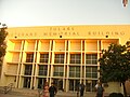 This is a picture of the front view of the Tulare Veterans Memorial Building.

References
- ^ http://www.ci.tulare.ca.us/
- ^ http://www.usacitiesonline.com/cacountytulare.htm#history
- ^ http://www.momomedia.com/CLPEF/camps.html
- ^ "Will Gerrymandered Districts Stem the Wave of Voter Unrest?". Campaign Legal Center Blog. Retrieved 2008-02-10.
- ^ http://www.fresnobee.com/2010/08/26/2055529/tulare-sued-over-at-large-election.html#storylink=mirelated
- ^ http://www.fresnobee.com/2010/10/11/2113706/tulare-vice-mayor-resigns-to-settle.html#storylink=mirelated
- ^ http://www.fresnobee.com/2010/09/17/2082725/racetrack-is-hot-issue-heading.html#storylink=mirelated
- ^ http://www.tcoe.k12.ca.us/
- ^ http://www.tcoe.k12.ca.us/Districts/CountySpecialEducation.shtm
- ^ http://www.tcoe.k12.ca.us/Districts/index.shtm
- ^ http://www.ci.tulare.ca.us/economic_development/climate.htm
- ^ Reichler, Joseph L., ed. (1979) [1969]. The Baseball Encyclopedia (4th edition ed.). New York: Macmillan Publishing. ISBN 0-02-578970-8.
((cite book)):|edition=has extra text (help) - ^ http://www.ci.tulare.ca.us/economic_development/transportation.htm
