Konteth Karlir
Mappa Leicestershire
Lavar: For'ard For'ard
Nebes Derivadow
Rannvro East Midlands
Enep 2 156 km² (konteth solempnytel)
2 083 km² (heb an awtoritas unnik)
Pennsita Karlir
Poblans (2004)
Doesedh
909 000 a drigoryon
421 / km²
ISO 3166-2 GB-LEC
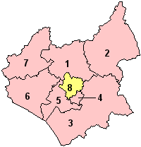
Ranndiryow
Ranndiryow Leicestershire
  1. Charnwood
  2. Melton
  3. Harborough
  4. Oadby ha Wigston
  5. Blaby
  6. Hinckley ha Bosworth
  7. North West Leicestershire
  8. Leicester (awtorita unnik)
Baner Karlir
Baner Karlir

Konteth Karlir yw konteth yn Pow Sows.


Stokk a-dro dhe Bow Sows yw an erthygel ma. Hwi a yll gweres Wikipedya der y efani.


Flag of England Contethow istorek Pow Sows

Contethow gwrys kyns 1889:
Bedfordshire • Berkshire • Buckinghamshire • Cargront • Cheshire • Cumberland • Derbyshire • Dewnans • Dorset • Durham • Essex • Evrek • Gloucestershire • Gwlas an Hav • Hampshire • Herefordshire • Hertfordshire • Huntingdonshire • Kernow • Kint • Lancashire • Leicestershire • Lincolnshire • Menow • Middlesex • Norfolk • Northamptonshire • Northumberland • Nottinghamshire • Rysoghen • Rutland • Shropshire • Staffordshire • Suffolk • Surrey • Sussex • Warwickshire • Westmorland • Wiltshire • Worcestershire