.mw-parser-output .hidden-begin{box-sizing:border-box;width:100%;padding:5px;border:none;font-size:95%}.mw-parser-output .hidden-title{font-weight:bold;line-height:1.6;text-align:left}.mw-parser-output .hidden-content{text-align:left}@media all and (max-width:500px){.mw-parser-output .hidden-begin{width:auto!important;clear:none!important;float:none!important))You can help expand this article with text translated from the corresponding article in German. (May 2023) Click [show] for important translation instructions.
Machine translation, like DeepL or Google Translate, is a useful starting point for translations, but translators must revise errors as necessary and confirm that the translation is accurate, rather than simply copy-pasting machine-translated text into the English Wikipedia.
Do not translate text that appears unreliable or low-quality. If possible, verify the text with references provided in the foreign-language article.
You must provide copyright attribution in the edit summary accompanying your translation by providing an interlanguage link to the source of your translation. A model attribution edit summary is Content in this edit is translated from the existing German Wikipedia article at [[:de:Alvier (Berg)]]; see its history for attribution.
You should also add the template ((Translated|de|Alvier (Berg))) to the talk page.
For more guidance, see Wikipedia:Translation.
| Alvier | |
|---|---|
 | |
| Highest point | |
| Elevation | 2,343 m (7,687 ft) |
| Prominence | 243 m (797 ft)[1] |
| Parent peak | Gamsberg |
| Isolation | 2.59 km (1.61 mi) |
| Coordinates | 47°06′35.1″N 09°24′53.4″E / 47.109750°N 9.414833°E |
| Geography | |
| Location | St. Gallen, Switzerland |
| Parent range | Appenzell Alps |
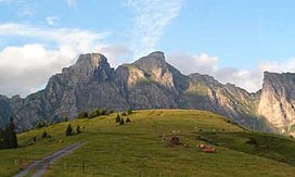
The Alvier (German pronunciation: [alˈfiːɐ̯] ⓘ) is a mountain in the Appenzell Alps, located halfway between Lake Walenstadt and the Rhine in the canton of St. Gallen. It is one of the main summits of the chain separating the valleys of the river Seez and the Rhine.
Although involving a long hike, the summit is easily accessible by trails from both sides.
