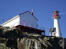
 The lighthouse in 2012 | |
 | |
| Location | Denman Island British Columbia Canada |
|---|---|
| Coordinates | 49°28′19.49″N 124°41′2.18″W / 49.4720806°N 124.6839389°W |
| Tower | |
| Constructed | 1891 (first) |
| Construction | fiberglass tower |
| Height | 7.5 metres (25 ft) |
| Shape | cylindrical tower with balcony and lantern |
| Markings | white tower, red lantern |
| Power source | solar power |
| Operator | Canadian Coast Guard[1] |
| Light | |
| First lit | 1989 (current) |
| Focal height | 22 metres (72 ft) |
| Characteristic | Fl W 5s. |
Chrome Island Lighthouse is a light station established in 1891 that assists traffic in the region of Deep Bay, British Columbia, Denman Island, and Hornby Island. It is currently a manned station, though in recent years the Canadian Coast Guard has considered automating it.
Along with electronic navigational aids, the five-second-flash lighthouse is about 21 metres (69 ft) above water level (depending on tides). The station has a helicopter landing deck and rescue boat.
The light is one of the 12 locations of the British Columbia Shore Station Oceanographic Program, and has collected coastal water temperature and salinity measurements for the Department of Fisheries and Oceans since 1961.[2]