This article has multiple issues. Please help improve it or discuss these issues on the talk page. (Learn how and when to remove these template messages) This article relies largely or entirely on a single source. Relevant discussion may be found on the talk page. Please help improve this article by introducing citations to additional sources.Find sources: "Ecuadorian Planning Zones" – news · newspapers · books · scholar · JSTOR (April 2023) This article needs additional or more specific categories. Please help out by adding categories to it so that it can be listed with similar articles. (April 2023) (Learn how and when to remove this message)
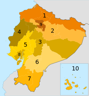
The planning zones of Ecuador are administrative organization entities made up of joint provinces or metropolitan districts in order to decentralize administrative activities of the Ecuadorian State.[1] The main agency in charge of zone planning is Senplades.

Planning zones

There are nine planning zones in Ecuador:[2]

  1. Ecuador Planning Zone 1 : Esmeraldas, Imbabura, Carchi, Sucumbíos
  2. Ecuador Planning Zone 2 : Pichincha, Napo, Orellana
  3. Ecuador Planning Zone 3 : Cotopaxi, Tungurahua, Chimborazo, Pastaza
  4. Ecuador Planning Zone 4 : Manabí, Santo Domingo de los Tsáchilas
  5. Ecuador Planning Zone 5 : Santa Elena, Guayas, Bolívar, Los Ríos, Galápagos
  6. Ecuador Planning Zone 6 : Cañar, Azuay, Morona Santiago
  7. Ecuador Planning Zone 7 : El Oro, Loja, Zamora Chinchipe
  8. Ecuador Planning Zone 8: Guayaquil, Samborondón, Durán
  9. Ecuador Planning Zone 9: Distrito Metropolitano de Quito

References

  1. ^ María Fernanda, López Sandoval (2015). "El sistema de planificación y el ordenamiento territorial para Buen Vivir en el Ecuador" (PDF). Geousp – Espaço e Tempo. 19 (2): 297-312. Retrieved 28 April 2023.
  2. ^ "Página web de la Senplades". Niveles de administración (in Spanish). Retrieved 30 March 2016.