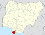
LGA and town in Bayelsa State, Nigeria
Ekeremor is one of the eight local government areas[1] (LGAs) in Bayelsa State,[2] Nigeria.[3] It borders[4] Delta State[5] and has a coastline of approximately 60 km on the Bight of Bonny. Its headquarters are in the town of Ekeremor in the northeast of the area.[6]
It has an area of 1,810 km2 and a population of 270,257 at the 2006 census.
The postal code of the area is 561.[7]
Demographics
Ekeremor LGA is home to members of the Ekeremor clan of the Ijaw ethnic group. According to the Nigeria 2006 Census, Ekeremor LGA has a population of roughly 270,000 people (53% male, 47% female).[8]
List of Towns and Villages in Ekeremor Local Government Area
The Ekeremor LGA consists of twenty eight (28) Towns and villages listed below:[9]
- Aiegbe
- Aleibiri
- Amabulour
- Ananagbene
- Angalawei-gbene
- Ayamassa
- Bown-Adagbabiri
- Ebikeme-Gbene
- Eduwini
- Egbemo-Angalabiri
- Ekeremor
- Feremoama
- Fontoru-Gbene
- Isampou
- Isreal o-Zion
- Lalagbene
- Ndoro
- Norhene
- Obrigbene
- Ogbogbene
- Ogbosuwar
- Oporoma
- Oyiakiri
- Peretou-Gbene
- Tamogbene
- Tamu-Gbene
- Tarakiri
- Tietiegbene
- Toru-Foutorugbene
- Aghoro
Politics
As of August 2007, Robinson Etolor was chairman of the local government council. However, there has been a long-running dispute over the post between Etulor and his predecessor Donald Daunemigha.[10]
Ekeremor LGA sends three representatives to the Bayelsa State House of Assembly.
Bayelsa State Deputy Governor Peremobowei Ebebi is a native of Aleibiri town in Ekeremor LGA. Before becoming deputy governor, he represented Ekeremor I constituency in the Bayelsa State House of Assembly.[11]
Ekeremor local government Chairman Dr. Bertola Perekeme has hailed the Supreme Court of Nigeria for upholding it’s a judgement on the Bayelsa State election.[12]
Climate
Ekeremor,a local government in Bayelsa State ,Nigeria. The wet season is warm and overcast, the dry season is cloudy and hot, and it is oppressive all through the year. Over the course of the year, the temperature typically varies from 71 °F to 87 °F and is rarely below 64 °F or above 89 °F.


