Original file (SVG file, nominally 1,414 × 922 pixels, file size: 441 KB)
| This is a file from the Wikimedia Commons. Information from its description page there is shown below. Commons is a freely licensed media file repository. You can help. |
Summary
| DescriptionOzark Trails road schematic.svg |
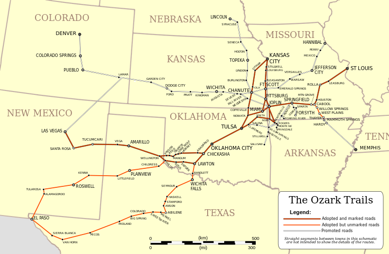
English: This is a schematic map of the Ozark Trails network of automobile roads established by local groups across several U.S. states in the early part of the twentieth century prior to the creation of the national numbered highway system. The network adopted local roads stretching from St. Louis, Missouri into New Mexico, with other associated roads reaching into Nebraska and Colorado. Parts of the Ozark Trails road network were predecessor segments of historic Route 66, which was an important cross-country route between Chicago and Los Angeles prior to the advent of the Interstate Highway System.
The information for this map was taken from an undated map found at http://www.drivetheost.com/ozarktrails.html which appears as though it may have been taken from a guide book published by the Ozark Trails Association, the body which organized the establishment of the network. Unlike that map, which is a schematic diagram much like a modern subway map, the creation of this map employed GIS data to properly position all towns and cities on a projected map of the pertinent states. As no information or data was found concerning the lay of the roads, they are represented as straight lines between the contected towns. Thus this map retains an element of a schematic insofar as details of the overland routes between towns and cities are not presented. This map is presented with a custom polyconic projection centered on the meridian at 95.15° west longitude. The properties of this projection are such that scale is constant along all parallels and along the central meridian. |
| Date | |
| Source | Own work |
| Author | Kbh3rd |
Licensing
- You are free:
- to share – to copy, distribute and transmit the work
- to remix – to adapt the work
- Under the following conditions:
- attribution – You must give appropriate credit, provide a link to the license, and indicate if changes were made. You may do so in any reasonable manner, but not in any way that suggests the licensor endorses you or your use.
- share alike – If you remix, transform, or build upon the material, you must distribute your contributions under the same or compatible license as the original.

|
Permission is granted to copy, distribute and/or modify this document under the terms of the GNU Free Documentation License, Version 1.2 or any later version published by the Free Software Foundation; with no Invariant Sections, no Front-Cover Texts, and no Back-Cover Texts. A copy of the license is included in the section entitled GNU Free Documentation License.http://www.gnu.org/copyleft/fdl.htmlGFDLGNU Free Documentation Licensetruetrue |


