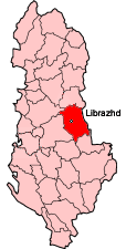
The District of Librazhd (Albanian: Rrethi i Librazhdit) is one of the thirty-six districts of Albania, part of Elbasan County. It has a population of 72,000 (2004 estimate), and an area of 1,102 km². It is in the east of the country, and its capital and administrative center is Librazhd.
Geography
Librazhdi district has an administrative border of 42km. The district is characterised by a mountainous landscape with scenic valleys (including Glacial valleys above 1,500 feet in the Polisi Mountains). The mighty River Shkumbin is sourced in and traverses through the district. The average altitude is 713 feet above sea level. The highest point is at the Red Peak of Shebeniku Mountain on the border with the Republic of Macedonia.
Climate
There is a continental climate. The average temperature is 13.4 degrees centigrade. The maximum recorded temperature in 1957 was 40.7oC while the minimum recorded temperature was in 1968 at -15.7oC.
Water Sources
Flora and Fauna
History & Culture
Kandavia
The Romans
The Ottoman Invasion
The role of Librazhd in Albanian national re-awakening
Librazhd since 1990
Cultural Traditions
Administration
The district of Librazhd is composed of two towns (Librazhd and Përrenjas), nine rural municipalities and 77 villages. The district consists of the following municipalities:
Population & Employment
According to the statistics taken in 1998 the district had a population of 82,411 habitants of which 29.7% of the population lived in either Librazhd and Përrenjas and the remaining 70.3% lived in villages in the countryside.
Religion
Sport
See: Librazhd