Manaung Township
မာန်အောင်မြို့နယ် | |
|---|---|
 Location in Kyaukphyu district | |
| Country | |
| State | Rakhine State |
| District | Kyaukpyu District |
| Time zone | UTC+6:30 (MST) |
Manaung (Burmese: မာန်အောင်မြို့နယ်) is a township of Kyaukpyu District in the Rakhine State of Western Myanmar. The principal town is Manaung. Manaung Township, situated on Manaung Island, consists of three islands: Manaung Island, Ye Kyun Island and Taik Kyun Island. Manaung is not only a township of Kyaukpyu District but also the second biggest island of Rakhine State in Myanmar.
The Bay of Bengal is located to the West and Northwest, Ramree Island in the Northeast, Ye Kyun Island in the South and Taungup in the East. Manaung Island, about 55 miles in circumference, is situated at 18'47 (898'N) and 93'98 (472'E) on the Rakhine Coast of Myanmar.
The highest mountain is 972 feet (296 m) high and the lowest level is 6 feet (1.8 m) above sea level. The population was 95927 on October 31, 2007.
There are 5 wards and 138 villages in Manaung Township.
There is one township stadium.
-
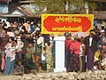 Entry Point of Manaung
 -
 Manaung Township Passenger Transportation
 -
 Manaung Township Timber Business
 -
 Manaung Township Goods Transportation
 -
 Manaung Township Agriculture
 -
 Manaung Township Communication
 -
 Manaung Township Business


.jpg)


