Highway 735 | ||||
|---|---|---|---|---|
| Ruta 735 | ||||
| Route information | ||||
| Maintained by Puerto Rico DTPW | ||||
| Length | 2.7 km[1] (1.7 mi) | |||
| Existed | 1953[2]–present | |||
| Major junctions | ||||
| South end | ||||
| North end | ||||
| Location | ||||
| Country | United States | |||
| Territory | Puerto Rico | |||
| Municipalities | Cayey, Cidra | |||
| Highway system | ||||
| ||||


Puerto Rico Highway 735 (PR-735) is a rural road located between the municipalities of Cayey and Cidra, Puerto Rico,[3][4] and it corresponds to an original segment of the historic Carretera Central.[2] The Arenas and La Liendre old bridges are located on this route.[5][6]
-
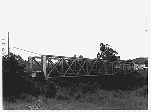 Arenas Bridge
 -
 La Liendre Bridge

