.mw-parser-output .hidden-begin{box-sizing:border-box;width:100%;padding:5px;border:none;font-size:95%}.mw-parser-output .hidden-title{font-weight:bold;line-height:1.6;text-align:left}.mw-parser-output .hidden-content{text-align:left}@media all and (max-width:500px){.mw-parser-output .hidden-begin{width:auto!important;clear:none!important;float:none!important))You can help expand this article with text translated from the corresponding article in French. (July 2020) Click [show] for important translation instructions.
Machine translation, like DeepL or Google Translate, is a useful starting point for translations, but translators must revise errors as necessary and confirm that the translation is accurate, rather than simply copy-pasting machine-translated text into the English Wikipedia.
Do not translate text that appears unreliable or low-quality. If possible, verify the text with references provided in the foreign-language article.
You must provide copyright attribution in the edit summary accompanying your translation by providing an interlanguage link to the source of your translation. A model attribution edit summary is Content in this edit is translated from the existing French Wikipedia article at [[:fr:Sarthe (rivière)]]; see its history for attribution.
You may also add the template ((Translated|fr|Sarthe (rivière))) to the talk page.
For more guidance, see Wikipedia:Translation.
| Sarthe | |
|---|---|
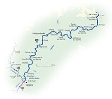
 The navigable river Sarthe between Morannes and Chemiré-sur-Sarthe | |
 | |
| Native name | La Sarthe (French) |
| Location | |
| Country | France |
| Physical characteristics | |
| Source | |
| • location | Perche |
| • elevation | 250 m (820 ft) |
| Mouth | |
• location | Maine |
• coordinates | 47°29′35″N 0°32′34″W / 47.49306°N 0.54278°W |
| Length | 313.9 km (195.0 mi) |
| Basin size | 7,864 km2 (3,036 sq mi)* |
| Discharge | |
| • average | 80 m3/s (2,800 cu ft/s)* |
| Basin features | |
| Progression | Maine→ Loire→ Atlantic Ocean |
| Notes | *excluding Loir |
The Sarthe (French pronunciation: [saʁt] ) is a 313.9-kilometre-long (195.0 mi) river in western France.[1] Together with the river Mayenne it forms the river Maine, which is a tributary to the river Loire.
Its source is in the Orne department, near Moulins-la-Marche. It flows generally southwest, through the following departments and towns:
- Orne: Le Mêle-sur-Sarthe, Alençon
- Sarthe: Fresnay-sur-Sarthe, Beaumont-sur-Sarthe, Le Mans, Sablé-sur-Sarthe
- Maine-et-Loire: Châteauneuf-sur-Sarthe, Tiercé, Angers
Its main tributaries are the Loir and the Huisne from the left, and the Vaige, the Erve and the Vègre from the right.[1]

