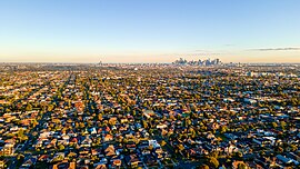
Suburb of Melbourne, Victoria, Australia
Thornbury () is an inner-city suburb in Melbourne, Victoria, Australia, 7 km (4.3 mi) north-east of Melbourne's Central Business District, located within the City of Darebin local government area. Thornbury recorded a population of 19,005 at the 2021 census.[1]
Thornbury is bordered by the Merri Creek to the west, and the Darebin Creek to the east. The heart of Thornbury is known as Thornbury Village,[2] and is located at the centre of Thornbury, at the intersection of High Street and Normanby Avenue/Clarendon Street.
Thornbury is shaped as a thin strip of land sandwiched between Northcote and Preston. Its east–west distance is four times its north–south distance. For 111 years, Thornbury was part of the former City of Northcote local government area, which existed from 1883 until June 1994. As such, Thornbury is universally understood to be a demographic and commercial satellite of Northcote, along with Westgarth, although the latter does not have its own postcode.
History
Etymology
The area's name is derived from the name of a property of early settler, Jobbo Smith, with the name dating to 1850. Smith named his property after a farm near his English birthplace.[3]
19th century
High Street had a cable tram by 1890. This ran the length of High Street from Northcote to Preston. By 1901, a railway line to its west connected to the central city line.[4] A cable tram engine house was built, with the building still existing on 628 High Street Thornbury. It contained both the engine house and the car shed.[3]
20th century
St Mary's Catholic Church was built in 1916.[5]
Geography
Thornbury's geology mainly consists of Silurian sedimentary rocks of the Melbourne Formation (formerly Dargile). River sediments overlay parts of the folded Silurian rocks, especially near Merri Creek and Darebin Creek that represent the western and eastern borders of the suburb respectively.
Urban structure
An area of Thornbury, referred to as the Thornbury Park Estate Precinct, consists of a mix of housing built in the Victorian era, late Federation and the interwar period. After a backlash from residents about the proposed demolition of a 1920s Church Manse on Comas Grove in particular, the local council established a temporary heritage overlay, protecting the buildings. Old buildings, some 100 years old, were regularly being demolished and replaced with newer buildings, and in some cases, apartments. The Thornbury Park Estate Precinct - Proposed Heritage Overlay established temporary protection, initiated in April 2022, and saved houses in the area from demolition [6]
Economy
The main commercial area in Thornbury is the High Street shopping strip, centred on Thornbury Village. Smaller shopping precincts are to be found on sections of St Georges Road, Wales Street and Station Street. The Northcote Pottery, founded in 1897 at Clyde Street, was closed in 2007.[7]
Thornbury has a long line of industry near Dundas Street (the border between Thornbury and Preston) and Station Street. It consists mainly of warehouses and scrap metal yards, with a few metal recycling centres and factories.
Transport
Active transport
The Merri Creek Trail and Darebin Creek Trail run on the west and east boundaries of Thornbury respectively, and are popular shared-use recreational paths used by cyclists and walkers.
Public transport
Train
Thornbury is served by one railway station: Thornbury, on the Mernda line.
Tram
Two tram routes service Thornbury, both operated by Yarra Trams:
Bus
Seven bus routes service Thornbury:
Sports
The Darebin International Sports Centre (DISC) is located in the John Cain Memorial Park, near the Darebin Creek in Thornbury. The Darebin International Sports Centre is the home of Football Federation Victoria, the State Football Centre (soccer), the State Lawn Bowls Centre and the State Cycling Centre, a velodrome with a 250m indoor timber cycling track. The Northcote Public Golf Course, run by the Northcote Golf Club, is located near the Merri Creek. It is also home to Flinders Park and the Holy Trinity Cricket Club (HTCC).


