The following is a sample layout Substitution template for Saskatchewan Highway articles. It may be subst'd into a new article. Please modify this template to suit Saskatchewan Highway format guidelines.
Do not edit this template page directly if you just want to create a new Highway # article.
See also: WikiProject Saskatchewan Roads
Images of roadway itself, exits, signage
[[Image:Highway photograph.svg|thumb|right|Photo caption]]
The shield can be added to articles with this template SK specific images and colours at ((User:Pomte/Template:SK road shield)) and ((Template:SK hwy tiny shield)) For their use see Saskatchewan Highway 2..Use the larger coding for the main article highway shield. Use municipal for highway numbers greater than 700 generally speaking (green shield)...use provincial for highway numbers less than 700. Some highways have their own shield such as Hwy 1, 6, 11, 16 for example. Use the tiny shields in the junction box for highways the article highway intersects.
New tiny shield
.
((Template:SK hwy tiny shield|provincial|12|align=left))
((jct|state=SK|Hwy|12))
<BR><BR>
((Template:SK hwy tiny shield|municipal|794|align=left))

((jct|state=SK|Hwy|794}
...Which result in....
 Hwy 12 Hwy 12

 Hwy 794 Hwy 794
[[File:Saskatchewan Highway 16.svg|20px]]
[[File:YellowheadShield.jpg|20px]
((jct|state=SK|Hwy|16))


 Hwy 16
((jct|state=SK|Hwy|1))
 Hwy 1
infobox template...
Hwy 1
infobox template...
((Infobox road
|marker_image=
|state=
|highway_name=
|name_notes=
|type=
|route=
|alternate_name=
|maint=
|section=
|map=
|length_mi=
|length_round=
|length_ref=
|length_notes=
|established=
|decommissioned=
|direction_a=
|terminus_a=
|beltway_city=
|junction=
|direction_b=
|terminus_b=
|counties=
|rural_municipalities=
|cities=
|system=[[List of Saskatchewan provincial highways|Saskatchewan provincial highways]]
|spur_type=
|spur_of=
|previous_type=
|previous_route=
|next_type=
|next_route=
|browse=
|commons=
|customcommons=
))
 
Highway 2 |
|---|
|
 |
|
| Maintained by Ministry of Highways and Infrastructure |
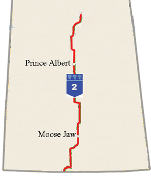
| Length | 809 km[1] (503 mi) |
|---|
|
| South end |  Montana Highway 24 at U.S.-Canadian border at Opheim, Montana - Port of West Poplar River, Saskatchewan Montana Highway 24 at U.S.-Canadian border at Opheim, Montana - Port of West Poplar River, Saskatchewan |
|---|
| Major intersections | Hwy 1
 Hwy 11 Hwy 11 Hwy 11 Hwy 11
Hwy 16
 Hwy 5 Hwy 5 Hwy 5 Hwy 5
 Hwy 41 Hwy 41 Hwy 41 Hwy 41
 Hwy 3 Hwy 3 Hwy 3 Hwy 3
 Hwy 55 Hwy 55 Hwy 55 Hwy 55
|
|---|
| North end |  Hwy 102 Hwy 102 in La Ronge Hwy 102 Hwy 102 in La Ronge |
|---|
|
|
|---|
|
| Country | Canada |
|---|
| Province | Saskatchewan |
|---|
| Rural municipalities | Old Post, Poplar Valley, Willow Bunch, Stonehenge, Lake of the Rivers, Sutton, Lake Johnston, Terrell, Baildon, Moose Jaw, Marquis, Dufferin, Sarnia, Big Arm, Wood Creek, Wood Creek, Wood River, Morris, Colonsay, Bayne, Hoodoo, Fish Creek, Hoodoo, St. Louis, Prince Albert, Buckland, Paddockwood, Lakeland , Northern Administration District |
|---|
| Major cities | Moose Jaw, Prince Albert |
|---|
|
|
|---|
|
|
|
|
Lead paragraph WP Lead
- Context - Highway # designates major roads intended for travel by the public between important destinations, such as cities, or communities. Saskatchewan's main roadways are located in the central/southern geographical land area of rolling prairie and grass land in a western Canadian prairie province.
- Characterization - Notable unique characteristics and characteristics commonly associated with it. Asphalt concrete, Bitumen, Paved, Gravel road, Dirt road, truck route, bridges, south-north, west-east, freeway, road, Collector road Dual carriageway Divided Highway Range road Highway, Length, Date Formed, Direction; From-To, major cities/communities, road surface...
- Explanation - briefly introduce the contents which may use the main subsections.
- Compare and contrast - Comparison to other current or defunct transportation methods of the highway path such as roadways, railways, red river cart trail, waterways of transportation of use in the province. The tundra or Canadian Shield area: fly in roadways, and ice highways.
- Criticism - road construction and soil type and highway repair, upgrades, future expansions or divisions, deer crossings, police patrol and highway markings, speed limits, ditch construction or railings, environmental or weather hazards.
Communities
NEWDO NOT USE: put the communities of the route into the travel route.
{|class="infobox" width="230px"
!style="background: #ccf;"|<big>Communities</big>
|-
|
*[[Lafleche, Saskatchewan|Lafleche]]
*[[Gravelbourg, Saskatchewan|Gravelbourg]]
*[[Shamrock, Saskatchewan]]
*[[Chaplin, Saskatchewan|Chaplin]]
|}
A paragraph in prose about the communities, towns, cities, villages along the route
Rural municipalties
new DO NOT USE. Add any
[[Rural Municipality|rural municipality (RM)]])
into the prose of the travel route
List these in the infobox in abbreviated format...don't use a separate table...in the infobox use either RM name or RM number.
Deprecated:
A paragraph in prose of rural municipalties that the route enters.
History
Construction date, previous mode of travel between the communities.
Major Attractions
| Major attractions
|
- National Historic Site, Louis Pierre Gravel
- Thomson Lake Regional Park
- Notukeu Creek
- Shamrock Regional Park
- Chaplin Lake
- Provincial Historic Site Cripple Creek
|
A paragraph in prose citing the major attractions such as lakes, big things, statues, historical markers, beaches, historical sites and buildings, national, regional and provincial parks.
- Physical geography that the highway travels through (area, unique features) See Geography of Saskatchewan for physiographic region
- Major Parks Check out ((Saskatchewan parks)) and add neighboring parks
- Transportation - that the highway assists, or has replaced such as rail, waterway, historic, current
Travel route
For route from west to east or south to north
The current terminology for distances in Canada is the metric system. In North America, the US still uses the Imperial system and mileages. The roads were surveyed according to townships on the 6 mile square.
- There is the handy
((Template:Convert)) template that does the conversions and the Manual of Style measurements properly.
((Template:Convert))
- miles to kilometres:
- ((convert|100|mi|km))
- kilometres to miles:
- ((convert|100|km|mi))
<ref name="Statistics"/>

<ref name="Class"/>

<ref name="AreaTransportation"/>

<ref name="HwyVolume"/>

<ref name="NationalHwySystem"/>

<ref name="Weight"/>

<ref name="ConstructionProjects"/>

<ref name="Surface type"/>

<ref name="Class">((cite web
| url         = http://www.highways.gov.sk.ca/adx/aspx/adxGetMedia.aspx?DocID=227,81,1,Documents&MediaID=1500&Filename=2007-08+Road+Classification.pdf
| title       = 2007-08 Road Classification Map 2007-08 Road Classification.pdf  ( 424.5 KB )
| accessdate  = 2009-02-08
| date        = 2007
| format      =Have to rename file as a pdf to open and view
| work        =Highways and Infrastructure  About Highways/Saskatchewan Maps
| publisher   = Saskatchewan Government
))</ref>

<ref name="AreaTransportation">((cite web
| url         =http://www.highways.gov.sk.ca/adx/aspx/adxGetMedia.aspx?DocID=227,81,1,Documents&MediaID=1499&Filename=2007-2008+ATPC.pdf
| title       =2007-08 Area Transportation Map 2007-2008 ATPC.pdf  ( 280.9 KB )
| accessdate  = 2009-02-08
| date        = 2007
| format      =Have to rename file as a pdf to open and view
| work        =Highways and Infrastructure  About Highways/Saskatchewan Maps
| publisher   = Saskatchewan Government
))</ref>

<ref name="HwyVolume">((cite web
| url         =http://www.highways.gov.sk.ca/adx/aspx/adxGetMedia.aspx?DocID=227,81,1,Documents&MediaID=1386&Filename=trafficvolume-2007.pdf
| title       =Highway Traffic Volume Map trafficvolume-2007.pdf  ( 1.5 MB )
| accessdate  = 2009-02-08
| date        = 2007
| format      =Have to rename file as a pdf to open and view
| work        =Highways and Infrastructure  About Highways/Saskatchewan Maps
| publisher   = Saskatchewan Government
))</ref>

<ref name="NationalHwySystem">((cite web
| url         =http://www.highways.gov.sk.ca/adx/aspx/adxGetMedia.aspx?DocID=227,81,1,Documents&MediaID=1501&Filename=2007-08+NHS.pdf
| title       =2007-08 National Highway System 2007-08 NHS.pdf  ( 339.5 KB )
| accessdate  = 2009-02-08
| date        = 2007
| format      =DHT internet maps (Have to rename file as a pdf to open and view)
| work        =Highways and Infrastructure  About Highways/Saskatchewan Maps
| publisher   = Saskatchewan Government
))</ref>

<ref name="Weight">((cite web
| url         =http://www.highways.gov.sk.ca/adx/aspx/adxGetMedia.aspx?DocID=227,81,1,Documents&MediaID=1502&Filename=2007-08+weight+map.pdf
| title       =2007-08 Weight Classification Map 2007-08 weight map.pdf  ( 478.5 KB )
| date        = 2007
| format      =Have to rename file as a pdf to open and view
| work        =Highways and Infrastructure  About Highways/Saskatchewan Maps
| publisher   = Saskatchewan Government
))</ref>

<ref name="ConstructionProjects">((cite web
| url         =http://www.highways.gov.sk.ca/adx/aspx/adxGetMedia.aspx?DocID=227,81,1,Documents&MediaID=1387&Filename=2008-09+major+project+map+final+version.pdf
| title       =2008-09 Highway Construction and Major Projects 2008-09 major project map final version.pdf  ( 695 KB )
| date        = 2007
| format      =Have to rename file as a pdf to open and view
| work        =Highways and Infrastructure  About Highways/Saskatchewan Maps
| publisher   = Saskatchewan Government
))</ref>

[[Asphalt concrete|asphalt concrete (AS)]]


<ref name="Surface type">((cite web
|last=Lau
|first=Tony
| url         =http://www.highways.gov.sk.ca/adx/aspx/adxGetMedia.aspx?DocID=227,81,1,Documents&MediaID=1461&Filename=surface.pdf
| title       =2007-08 Saskatchewan Highway Surface Type surface.pdf  ( 302 KB )
| date        = 2007-08
| format      =DHT internet map (Have to rename file as a pdf to open and view)
| work        =Highways and Infrastructure  About Highways/Saskatchewan Maps
| publisher   = Saskatchewan Government
))</ref>


<ref name="ExplainSKRoads">((cite web
| last= Lazic
| first = Zvjezdan
| url         =http://www.tac-atc.ca/english/pdf/conf2003/lazic1.pdf
| title       =From Road Condition Data Collection to Effective
Maintenance Decision Making:
| date        = 2003
| format      =pdf
| work        =Saskatchewan Highways and Transportation (SHT)
| publisher   = Saskatchewan Government
))</ref>
[2][3][4][5][6][7][8][9]
[10]
List/Junctions/Major Intersections/Placenames
Intersections
For route from west to east or south to north
Use this template for ease of tabular formation. For example Saskatchewan Highway 33. Be sure to change county to county_special as well as location to location_special
Template:Jctint which is a template for generating a junction list for a route article. Use the modified template SKinttop to achieve headings of Rural municipality and kilometer rather than mile.
((SKinttop|length_ref=<ref name="Micro">((cite map
  |publisher =  Microsoft Corporation Redmond Washington
  |title = Microsoft Streets and Tips
  |url =
  |edition = 2004
  |section =
  |accessdate = 2008-02-10))</ref>))
((Jctint
|county_special
|cspan=
|location_special=
|lspan=
|type=
|mile=
|road=
|notes=
))
((Jctbtm))
[1]
Collector-express sections
Service centres
Paragraph to cite- weigh scales, gas stations, grain elevators, RV dump stations, stop over areas
Lane configuration
paragraph about the lanes from west to east or south to north
<div class="references-small"><references/></div>
Cite your sources via Citation Templates in the article itself following the new fact or quotation added.
<ref name="NameWeb">((cite web
  | last =
  | first =
  | authorlink =
  | coauthors =
  | title =
  | work =
  | publisher =
  | date =
  | url =
  | format =
  | doi =
  | accessdate =2008-02-14 ))</ref>
To use this same web site again just use this code...
<ref name="NameWeb"/>
After article is created by adding this substitution template, click the link at the bottom of the page called What links here If these wikipedia article are already a part of the main Saskatchewan Highway article, this is best, otherwise add them here in alphabetical order.
List related internal (Wikipedia) articles in alphabetical order. Common nouns are listed first. Proper nouns follow.


.svg)
.svg)

.svg)
