| This page is an archive. Do not edit the contents of this page. Please direct any additional comments to the current main page. |

update
_(Ireland).svg)
- Request
- The Map incorrectly shows the green party seat in Ireland south as the 5th seat becoming active after Brexit, rather than the second Fine Gael seat.
- Request
- This map say not the than 2019_European_Parliament_election_in_Ireland#Constituency_changes; I hope @Spleodrach:Diff could explain more. Habitator terrae (talk) 16:12, 24 May 2019 (UTC)
- Discussion
There's nothing to change here. I already updated this map a while back to add the new constituency boundaries. --RaviC (talk) 12:26, 26 May 2019 (UTC)
Update Request
-
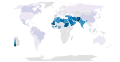 Global prevalence of consanguinity

- Article(s)
- Cousin marriage
- Request
- Sri Lanka needs to be coloured "grey". I noticed an error on the map regarding Sri Lanka. The source attributed to the map is comprised of varied data compiled from different sources. As a result, some of the data is large scale while others are small scale and the data comes from different years. The data attributed to Sri Lanka is data from a sample in a town in Sri Lanka from 1973 and does not represent the entire population, not to mention that the data is probably outdated. By colouring it grey it will keep it in line with other countries like Cambodia where only isolated populations were studied. -- 2001:8003:4E41:F200:FC45:DF8:3A17:67C3 (talk) 07:11, 7 June 2019 (UTC)
- Discussion
Request how to make a map indicating the countries Iceland and Turkey
Hi, I wrote an article about Iceland-Turkey relations. I also made my own map indicating the countries Iceland and Turkey. I did not manage however to make a regular map indicating the two countries. Can you help me in creating this?
Thank you!
-
Description of first imageDescription of first image
-
Description of second image (if needed)Description of second image (if needed)
-
Description of third image (if needed; don't request too many at once, though)Description of third image (if needed; don't request too many at once, though)
- Article(s)
Turkey-Iceland relations
Demographic maps
Good afternoon.
I would love if anybody here would be able to make a new set of demographic maps for the minorities of Romania. We already have a map for almost all of them, but they all are based on the 2002 population census, making them outdated (the last Romanian population census was in 2011). Currently, I am not looking for a map in particular, but I think that a map for the Czechs of Romania would be the best start. Here is the design that I want the new set of maps to be based on:
.png)
Thank you for taking your time reading this.
VladGhinea (talk) 14:08, 15 June 2019 (UTC)
Relief map of Northern California
-
 Relief map of California
 -
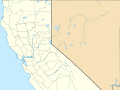 Northern California in ((Location Map))


- Article(s)
- Numerous potential applications; I intend to use it in Turtle Island (book)
- Request
- Hi! I'd like to make a request for a relief map of Northern California that can be used with Module:Location map/data/USA California Northern in Template:Location map. The map would be a crop of the relief map on the left with the precise borders of the map on the right, so that coordinate inputs used with the template would be located accurately on the relief map.
- If it makes sense to knock out a few of these in a row for efficiency's sake, an equivalent relief map could also be made for Module:Location map/data/USA California Southern. But I'm only looking for Northern California. Thank you in advance! —BLZ · talk 21:42, 3 June 2019 (UTC)

![]() Done --RaviC (talk) 18:10, 23 June 2019 (UTC)
Done --RaviC (talk) 18:10, 23 June 2019 (UTC)
European Games hosts
-
 Map of the hosts of the European Games

- Article(s)
- Request
- Can you add "2019" since it will be held this year in Minsk? -- RainbowSilver2ndBackup (talk) 13:18, 11 June 2019 (UTC)
- Discussion
![]() Done --RaviC (talk) 18:22, 23 June 2019 (UTC)
Done --RaviC (talk) 18:22, 23 June 2019 (UTC)
Request - map of Fez
-
 Satellite image of the city

- Article(s)
- List of car-free places
- Probably also Fes, Fes el Bali and Fes Jdid
- Request
I've actually made an image but I'd like it to be made into a map module for use on those Articles. The reason i've posted here is I made a request then made the map myself by screenshotting OpenStreetMap. Thanks. - Gave2haze (talk) 22:24, 11 June 2019 (UTC)
- Discussion
You could do this quite easily using geojson.io, and paste the code produced into a mapframe like this:
<mapframe text="Map." latitude="insert here" longitude="insert here" zoom="11" width="300" height="300" align="left">

code inserted in this space

</mapframe>
--RaviC (talk) 12:43, 26 June 2019 (UTC)
Antechinus
Hi, I have a request for a map of the distribution of all Antechinus species in Australia. This source provides all the necessary information I am just unsure how to make the map.[1]
- ^ Mutton, Thomas; Phillips, Matthew; Fuller, Susan; Littica, Bryant; Andrew, Baker (2019). "Systematics, biogeography and ancestral state of the Australian marsupial genus Antechinus (Dasyuromorphia: Dasyuridae)". Zoological Journal of the Linnean Society. 186 (2): 553–568.
Request for New River (Belize) map

-
Description of first imageDescription of first image
- Article(s)
- New River (Belize)
- Request
- Could someone make a map of New River in Orange Walk, Belize?… -- Josh95m (talk) 05:23, 30 June 2019 (UTC)
- Discussion
It flows from the New River Lagoon through Guinea Grass, Carmelita, Orange Walk Town, and into Chetumal Bay.