
This page provides conventions for the creation of locator maps.
Usage: Locator maps are first create blank maps aiming to be derivated into several specific Locator maps, Areas maps, Historical maps, Exchange maps.
Creation: Locator maps are conveniently derivate from country or wider area Location maps (blank). The map maker has to color the ocean, land, rivers, subject area, to the Locator maps conventional colours. Locator maps are very basic, and should not have, or have very few labels. Their aim is to show the geographical occupation in a wider context, not to explain this occupation.
Convention[edit]
| Subject | Colorimetry (RGB/hex) |
|---|---|
| Landmasses | |
| Toponymes (names) | #000000
R:0 G:0 B:0 |
| Territory of interest / Marked / Focus | #C12838
R:193 G:40 B:56 |
| Surrounding territories (Internal). | #FDFBEA
R:253 G:251 B:234 |
| Surrounding landmass (Outside) | #DFDFDF
R:223 G:223 B:223 |
| Background D (opacity 50%) | #C1283880
R: G: B: |
| Foreground C (opacity 50%) | #FDFBEA80
R: G: B: |
| Circle marker opacity, glow effect, zoom box: scale effect (opacity 25%) | #C1283840
R: G: B: |
| Political borders. Country, state, and province borders. Nuance is provided by line styling. |
#656565
R:101 G:101 B:101 |
| Water. | |
| Hydronymes (names). | #1278AB
R:18 G:120 B:171 |
| Rivers; coastlines for lakes, oceans. | #1278AB
R:18 G:120 B:171 |
| Water bodies: oceans, seas or lakes. | #C7E7FB
R:199 G:231 B:251 |
| Helper | |
| Zoom box shadow (opacity 50%) | #65656580
R: G: B: |
|
Naming (upload):
| |
Gallery of examples[edit]
| This Wikipedia page may require cleanup to meet Wikipedia's quality standards. No cleanup reason has been specified. Please help improve this Wikipedia page if you can; the talk page may contain suggestions. |
-
 Note: This widely used scheme should now become the semi-official locator style.
 -
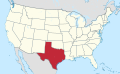 State within its larger union (USA)
 -
 Zoomed in territory with circle markers
 -
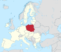 Country within its larger union (European Union)
 -
 Country w/o context
-en.svg)
.svg)
_(zoom).svg)
.svg)
.svg)
Ancient scheme[edit]
Extended content
| ||||||||||||||||||
|---|---|---|---|---|---|---|---|---|---|---|---|---|---|---|---|---|---|---|
|
This 2008 scheme has been supersed by the 2012 scheme.
| ||||||||||||||||||
See also[edit]
- Commons:Category:SVG locator maps (location map scheme)
- Wikipedia:WikiProject Maps/Conventions/Locator maps (2008) - supersed
- Hack, Hans; Aisch, Gregor (Oct 10, 2018), Introducing Locator Maps in Datawrapper, Datawrapper
- Hack, Hans; Aisch, Gregor (Oct 10, 2018), Locator Maps App, Datawrapper
Map conventions and Map Project | |||
|---|---|---|---|
 | Conventions set |  | |
| Drafts | |||
| Others |
| ||