Caramoran
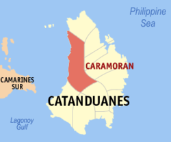
Mapa ning Catanduanes ampong Caramoran ilage
Map
Puuk: 13°59'N, 124°8'E
BansaFilipinas
LabuadLabuad Bicol (Rehiyong V)
LalawiganCatanduanes
TuknanganBalen
MitatagAgostu 29, 1948
Barangay27
Sukad
 • Kabilugan263.74 km2 (101.83 sq mi)
Elebasyun
41 m (135 ft)
Populasyun
(Sensu ning 1 Mayu 2020)
 • Kabilugan32,114
 • Densidad120/km2 (320/sq mi)
 • Pamimalemale
6,573
Economia
 • Uryanpangatlu yang klasing balen
 • Panakitan₱151,053,457.52 (2020)
 • Activos₱342,317,525.68 (2020)
 • Pasivos₱119,097,186.58 (2020)
 • Gastos₱166,410,705.87 (2020)
Kodigo Postal
4808
PSGC
IDD:area code +63 (0)52
AmanuCentral Bikol
Southern Catanduanes Bikol
Tagálug
Websaytwww.caramoran-catanduanes.gov.ph

Ing Balen ning Caramoran pang4 yang klasing balen king lalawigan ning Catanduanes, Filipinas. Agpang keng 1 Mayu 2020 ning sensus, atin yang populasyun a 32,114 a katau kareng 6,573 a pamimalemale.

Deng Barangay

Ing Caramoran atin yang 27ng barangay.

  • Baybay (Pob.)
  • Bocon
  • Bothoan (Pob.)
  • Buenavista
  • Bulalacao
  • Camburo
  • Dariao
  • Datag East
  • Datag West
  • Guiamlong
  • Hitoma
  • Icanbato (Pob.)
  • Inalmasinan
  • Iyao
  • Mabini
  • Maui
  • Maysuran
  • Milaviga
  • Panique
  • Sabangan
  • Sabloyon
  • Salvacion
  • Supang
  • Toytoy (Pob.)
  • Tubli
  • Tucao
  • Obi

Demograpiku

Sensus ning Populasyun
Caramoran
TaunPop.±% p.a.
1903 1,914—    
1948 9,619+3.65%
1960 13,384+2.79%
1970 17,540+2.74%
1975 18,055+0.58%
1980 19,386+1.43%
1990 20,999+0.80%
1995 21,963+0.84%
2000 23,790+1.73%
2007 25,618+1.03%
2010 28,063+3.37%
2015 30,056+1.32%
2020 32,114+1.31%
Sanggunian: Philippine Statistics Authority[1][2][3][4]

Panibatan

  1. Census of Population (2015). "Total Population by Province, City, Municipality and Barangay". Total Population by Province, City, Municipality and Barangay. PSA. 
  2. Census of Population and Housing (2010). "Total Population by Province, City, Municipality and Barangay". Total Population by Province, City, Municipality and Barangay. NSO. 
  3. Censuses of Population (1903–2007). "Table 1. Population Enumerated in Various Censuses by Province/Highly Urbanized City: 1903 to 2007". Table 1. Population Enumerated in Various Censuses by Province/Highly Urbanized City: 1903 to 2007. NSO. https://archive.org/download/PhilippinesCensusofPopulationLGUs19032007/Region%205%20Bicol%20Region%20Philippines%20Census%20of%20Population%201903%20-%202007.xls. 
  4. Province of Catanduanes. Municipality Population Data. Local Water Utilities Administration Research Division. Retrieved on [[Disiembri 17, 2016]].

Suglung Palwal