| |||||||||
| Peka Amanu | English | ||||||||
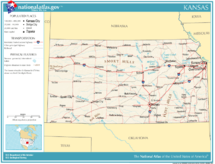
| Tungku Pekamaragul a Lakanbalen |
Topeka Wichita | ||||||||
| Lapad - Eganagana - Lapad - Kaba - % danum - Latitude - Longitude |
Ranku 15th 82,277 sq mi 213,096 km² 211 milya 340 km 400 milya 645 km 0.56 37°N to 40°N 94°38'W to 102°1'34"W | ||||||||
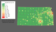
| Populasyun - Total (2000) - Pangasiksik |
Ranku 32nd 2,688,418 32.9/sq. mi 12.7/km² (40th) | ||||||||
| Elevation - Pekamatas a lugal - Kaustuan - Pekamababang Lugal |
Mount Sunflower—4,039 pie 1,231 m 2,000 pie 600 m 679 pie 207 m | ||||||||
| Pangatanggap keng Union | January 29, 1861 (34th) | ||||||||
| Gobernador Deng U.S. Senators |
Jeff Colyer (R) Jerry Moran (R) Pat Roberts (R) | ||||||||
| Oras zona | Central : UTC-6/-5 Mountain: UTC-7/-6 Counties are Central except for 4 counties on western border. | ||||||||
| Abbreviations | KS US-KS | ||||||||
| Web site | www.kansas.gov | ||||||||


| State ning Kansas | |
|---|---|
| Tungku: Topeka
| |
| Labuad: Cherokee Strip | Flint Hills | High Plains | Kansas City Metropolitan Area | Smoky Hills | Red Hills
| |
| Peka Syudad: Dodge City | Emporia | Garden City | Hays | Hutchinson | Junction City | Kansas City | Lawrence | Leavenworth | Leawood | Lenexa | Manhattan | Olathe | Overland Park | Pittsburg | Prairie Village | Salina | Shawnee | Topeka | Wichita
| |
| Deng Counties: Allen | Anderson | Atchison | Barber | Barton | Bourbon | Brown | Butler | Chase | Chautauqua | Cherokee | Cheyenne | Clark | Clay | Cloud | Coffey | Comanche | Cowley | Crawford | Decatur | Dickinson | Doniphan | Douglas | Edwards | Elk | Ellis | Ellsworth | Finney | Ford | Franklin | Geary | Gove | Graham | Grant | Gray | Greeley | Greenwood | Hamilton | Harper | Harvey | Haskell | Hodgeman | Jackson | Jefferson | Jewell | Johnson | Kearny | Kingman | Kiowa | Labette | Lane | Leavenworth | Lincoln | Linn | Logan | Lyon | Marion | Marshall | McPherson | Meade | Miami | Mitchell | Montgomery | Morris | Morton | Nemaha | Neosho | Ness | Norton | Osage | Osborne | Ottawa | Pawnee | Phillips | Pottawatomie | Pratt | Rawlins | Reno | Republic | Rice | Riley | Rooks | Rush | Russell | Saline | Scott | Sedgwick | Seward | Shawnee | Sheridan | Sherman | Smith | Stafford | Stanton | Stevens | Sumner | Thomas | Trego | Wabaunsee | Wallace | Washington | Wichita | Wilson | Woodson | Wyandotte | |
| Dake Politiku ning United States | |
|---|---|
| States | Alabama | Alaska | Arizona | Arkansas | California | Colorado | Connecticut | Delaware | Florida | Georgia | Hawaii | Idaho | Illinois | Indiana | Iowa | Kansas | Kentucky | Louisiana | Maine | Maryland | Massachusetts | Michigan | Minnesota | Mississippi | Missouri | Montana | Nebraska | Nevada | New Hampshire | New Jersey | New Mexico | New York | North Carolina | North Dakota | Ohio | Oklahoma | Oregon | Pennsylvania | Rhode Island | South Carolina | South Dakota | Tennessee | Texas | Utah | Vermont | Virginia | Washington | West Virginia | Wisconsin | Wyoming |
| Federal district | District of Columbia |
| Insular areas | American Samoa | Guam | Northern Mariana Islands | Puerto Rico | Virgin Islands |
| COFA | Republic of the Marshall Islands | Republic of Palau | Federated States of Micronesia |
| Minor outlying islands | Baker Island | Howland Island | Jarvis Island | Johnston Atoll | Kingman Reef | Midway Atoll | Navassa Island | Palmyra Atoll | Wake Island |


