Cayuta, New York | |
|---|---|
 Cayuta in 2022 | |
| Nickname: New York's Best Town | |
 Cayuta, New York Location within the state of New York | |
| Coordinates: 42°16′36″N 76°40′8″W / 42.27667°N 76.66889°W | |
| Country | United States |
| State | New York |
| County | Schuyler |
| Area | |
| • Total | 20.32 sq mi (52.63 km2) |
| • Land | 20.32 sq mi (52.63 km2) |
| • Water | 0.00 sq mi (0.00 km2) |
| Elevation | 1,086 ft (331 m) |
| Population (2020)[source?] | |
| • Total | 510 |
| • Estimate (2024) | 516 |
| • Density | 26.18/sq mi (10.11/km2) |
| Time zone | UTC-5 (Eastern (EST)) |
| • Summer (DST) | UTC-4 (EDT) |
| ZIP code | 14824 |
| Area code | 607 |
| FIPS code | 36-13112 |
| GNIS feature ID | 0978805 |
Cayuta is a hamlet and town in Schuyler County, New York, United States. As of the 2020 census, 510 people lived there.
Cayuta occupies the southeastern corner of the county. It is northeast of Elmira. The town is part of the Elmira Metropolitan Statistical Area.
| Historical population | |||
|---|---|---|---|
| Census | Pop. | %± | |
| 1820 | 1,889 | — | |
| 1830 | 642 | −66.0% | |
| 1840 | 835 | 30.1% | |
| 1850 | 1,035 | 24.0% | |
| 1860 | 708 | −31.6% | |
| 1870 | 641 | −9.5% | |
| 1880 | 601 | −6.2% | |
| 1890 | 560 | −6.8% | |
| 1900 | 459 | −18.0% | |
| 1910 | 345 | −24.8% | |
| 1920 | 282 | −18.3% | |
| 1930 | 258 | −8.5% | |
| 1940 | 311 | 20.5% | |
| 1950 | 459 | 47.6% | |
| 1960 | 538 | 17.2% | |
| 1970 | 557 | 3.5% | |
| 1980 | 566 | 1.6% | |
| 1990 | 599 | 5.8% | |
| 2000 | 545 | −9.0% | |
| 2010 | 556 | 2.0% | |
| 2020 | 510 | −8.3% | |
| 2024 (est.) | 516 | [2] | −7.2% |
| U.S. Decennial Census[3] | |||
42°16′54″N 76°41′49″W / 42.28167°N 76.69694°W
Municipalities and communities of Schuyler County, New York, United States | ||
|---|---|---|
| CDPs | 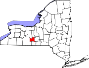 | |
| Towns | ||
| Villages |
| |
| Hamlets |
| |