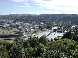
Gisborne District
Te Tai Rāwhiti | |
|---|---|
District and Unitary region | |
 | |
 Gisborne District in New Zealand | |
| Coordinates: 38°40′00″S 178°01′00″E / 38.66667°S 178.01667°E | |
| Country | New Zealand |
| Region | Gisborne Region |
| Wards |
|
| Seat | Gisborne |
| Government | |
| • Mayor | Rehette Stoltz |
| • Deputy Mayor | Josh Wharehinga |
| • Territorial authority | Gisborne District Council |
| Area | |
| • Land | 8,385.29 km2 (3,237.58 sq mi) |
| Population (June 2022)[1] | |
| • Territorial | 52,100 |
| • Urban | 37,700 |
| Area code | 06 |
| HDI (2021) | 0.893[2] very high · 15th |
| Website | www |
Gisborne (Māori: Te Tai Rāwhiti, lit. 'East Coast') is one of the 16 regions of New Zealand. It is on the North Island. Its largest city is Gisborne.