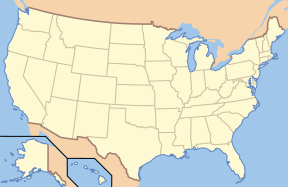
((Superimpose)) is a utility which superimposes one image over another, and positions it relative to the top left corner of the bottom image. Although the original idea was to place a dot on a locator map based on editable coordinates, it can be used to precisely overlay any two images for any reason.
Usage
Example
((Superimpose
  | base = US_Locator_Blank.svg
  | base_width = 288px
  | base_alt = Located in north central Colorado, which in turn is just west of the center of the U.S.
  | base_caption = United States Locator Map
  | float = Red Dot.svg
  | float_width = 10px
  | x = 95
  | y = 80
))
Using the Template
To get started, you can simply copy this blank definition into your page, and fill in the data.
((Superimpose
  | base =
  | base_width =
  | base_alt =
  | base_caption =
  | float =
  | float_width =
  | x =
  | y =
))
The following blank definition includes all the parameters, including those less-commonly used.
((Superimpose
  | base =
  | base_width =
  | base_alt =
  | base_caption =
  | base_link =
  | float =
  | float_alt =
  | float_width =
  | float_caption =
  | float_link =
  | x =
  | y =
))
Parameter Definitions
- base: File name of the base (bottom) image
- base_width: Width to display the base image, in pixels
- base_alt: Alt text for the image, for visually impaired readers; see Wikipedia:Alternative text for images. This normally describes the combination of the two images.
- base_caption: Text to show when a user's mouse hovers over the base image; ignored if base_link is specified to be empty
- base_link: Name of page that the user should be sent to if they click on the base image. The special value "
file:", stands for the file page for the base image. If empty, nothing happens if the user clicks on the base image. The default is "file:". - float: File name of the top image
- float_width: Width to display the top image, in pixels
- float_alt: Alt text for the top image. This is needed only if float_link is nonempty. Normally the alt text for the base image describes the combination of the two images, and this parameter is not needed.
- float_caption: Text to show when a user's mouse hovers over the top image; ignored if float_link is missing or empty
- float_link: Name of page that the user should be sent to if they click on the top image. This acts like base_link, except it is for the top image, and it defaults to empty.
- x: distance to offset the top image from the left edge of the base image, in pixels or any other CSS-standard units
- y: distance to offset the top image from the top edge of the base image, in pixels or any other CSS-standard units
A Note about the Locator Dot
I originally built this template thinking I could use an SVG file with transparency (mostly for the dot in locator maps). However, it seems Internet Explorer users can't handle transparent PNGs without a fix that Wikimedia's not yet delivering, so for now I recommend using the GIF version in the example above. When IE better supports PNGs, we can swap the better format back in. —Papayoung ☯ 02:06, 26 October 2005 (UTC)
追蹤分類
參見
- ((Superimpose2)), supports more layer superimposition.
- ((Location map)), places a single image over another at a map coordinate location
- ((Lageplan)), related template to Location map with specific features
| 上述文档嵌入自Template:Superimpose/doc。 (编辑 | 历史) 编者可以在本模板的沙盒 (创建 | 镜像)和测试样例 (创建)页面进行实验。 请在/doc子页面中添加分类。本模板的子页面。 |
