| |
|
|
Introduction


A mountain is an elevated portion of the Earth's crust, generally with steep sides that show significant exposed bedrock. Although definitions vary, a mountain may differ from a plateau in having a limited summit area, and is usually higher than a hill, typically rising at least 300 metres (980 ft) above the surrounding land. A few mountains are isolated summits, but most occur in mountain ranges.
Mountains are formed through tectonic forces, erosion, or volcanism, which act on time scales of up to tens of millions of years. Once mountain building ceases, mountains are slowly leveled through the action of weathering, through slumping and other forms of mass wasting, as well as through erosion by rivers and glaciers.
High elevations on mountains produce colder climates than at sea level at similar latitude. These colder climates strongly affect the ecosystems of mountains: different elevations have different plants and animals. Because of the less hospitable terrain and climate, mountains tend to be used less for agriculture and more for resource extraction, such as mining and logging, along with recreation, such as mountain climbing and skiing.
The highest mountain on Earth is Mount Everest in the Himalayas of Asia, whose summit is 8,850 m (29,035 ft) above mean sea level. The highest known mountain on any planet in the Solar System is Olympus Mons on Mars at 21,171 m (69,459 ft). The tallest mountain including submarine terrain is Mauna Kea in Hawaii from its underwater base at 9,330 m (30,610 ft) and some scientists consider it to be the tallest on earth. (Full article...)
Selected mountain-related landform

A rift valley is a linear shaped lowland between several highlands or mountain ranges produced by the action of a geologic rift. Rifts are formed as a result of the pulling apart of the lithosphere due to extensional tectonics. The linear depression may subsequently be further deepened by the forces of erosion. More generally the valley is likely to be filled with sedimentary deposits derived from the rift flanks and the surrounding areas. In many cases rift lakes are formed. One of the best known examples of this process is the East African Rift. On Earth, rifts can occur at all elevations, from the sea floor to plateaus and mountain ranges in continental crust or in oceanic crust. They are often associated with a number of adjoining subsidiary or co-extensive valleys, which are typically considered part of the principal rift valley geologically. (Full article...)
Selected mountain range

Cordillera de Maribios (or Cordillera de Marrabios) is a mountain range in León and Chinandega departments, western Nicaragua, at and about 64.4 km (40 mi) long. It is a volcanic range comprised most notably by San Cristóbal 1745 m, Pilas 983 m, Telica 1060 m, Cerro Negro 450 m, and Momotombo 1258 m. (Full article...)
Selected mountain type

An ultra-prominent peak, or ultra for short, is a mountain summit with a topographic prominence of 1,500 metres (4,900 ft) or more; it is also called a P1500. The prominence of a peak is the minimum height of climb to the summit on any route from a higher peak, or from sea level if there is no higher peak. There are approximately 1,524 such peaks on Earth. Some well-known peaks, such as the Matterhorn and Eiger, are not ultras because they are connected to higher mountains by high cols and thus do not achieve enough topographic prominence.
The term "ultra" originated with earth scientist Steve Fry, from his studies of the prominence of peaks in Washington in the 1980s. His original term was "ultra major mountain", referring to peaks with at least 1,500 metres (4,900 ft) of prominence. (Full article...)
Selected climbing article
(')
Related portals
General images
-
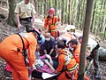 Mountain rescue team members and other services attend to a casualty in Freiburg Germany. (from Mountain rescue)
 -
 Climber approaching the summit of Manaslu at 8,163 metres (from Mountaineering)
 -
 Mountaineers proceed across snow fields on South Tyrol; other climbers are visible further up the slopes. (from Mountaineering)
 -
-
 Chimborazo, Ecuador, whose summit is the point farthest away from the Earth's center (from Mountain)
 -
 Mount Everest, Earth's highest mountain (from Mountain)
 -
 Tropical montane forest at around 2,000 m in Malaysia (from Montane ecosystems)
 -
 Choppering out the injured – with Mt. Forbes in the background (from Mountain rescue)
 -

-
 Iranian oak scrub in the Zagros Mountains (from Montane ecosystems)
 -
 Everest is highest from sea level (green), Mauna Kea is highest from its base (orange), Cayambe is farthest from Earth's axis (pink) and Chimborazo is farthest from Earth's centre (blue) (from Mountain)
 -

-

-

-
 A mountain rescue team in Iran moving a casualty. (from Mountain rescue)
 -

-
 Mountaineers, c. 1900 (from Mountaineering)
 -
 Edelweiss, a plant associated with mountain sports (from Mountaineering)
 -

-
 The Andes, the longest mountain range on the surface of the Earth, have a dramatic impact on the climate of South America (from Mountain range)
 -
 Antique climbing tools (from Mountaineering)
 -

-
Mountaineers climbing in South Tyrol (from Mountain)
-
 The Ocean Ridge, the world's longest mountain range (chain) (from Mountain range)
 -
 Fuji volcano (from Mountain)
 -
 Alpine flora near Cascade Pass (from Montane ecosystems)
 -
 The Namcha Barwa Himal, east part of the Himalayas as seen from space by Apollo 9 (from Mountain range)
 -
 Winter campers bivouaced in the snow (from Mountaineering)
 -
 This 1848 "Sketch showing the actual elevation of the Snow Line in different Latitudes" by Alexander Keith Johnston shows the snow lines of mountains in America, Europe and Asia (from Snow line)
 -
-
 Car of Horská služba (Czech Republic) (from Mountain rescue)
 -
 Fixed lines and ladders are distinguishing characteristics of expedition style mountaineering (from Mountaineering)
 -
 The northern Urals at high latitude and elevation have an alpine climate and barren ground. (from Mountain)
 -

-

-

-

-
 Stretcher box in Cumbria, England, prepositioned equipment saves mountain rescue teams having to trudge up mountains with it. (from Mountain rescue)
 -
 A stand of mountain birch at around 750 m in Trollheimen, typical of Scandinavian subalpine forests (from Montane ecosystems)
 -

-
 British mountaineer William Cecil Slingsby became known as the father of Norwegian mountaineering and contributed greatly to its popularization with his classic book Norway, the Northern Playground (from Mountaineering)


.jpg)


.jpg)


.jpg)


Selected skiing article

Telemark skiing is a skiing technique that combines elements of Alpine and Nordic skiing, using the rear foot to keep balance while pushing on the front foot to create a carving turn on downhill skis with toe-only bindings. Telemark skiing is named after the Telemark region of Norway, where the discipline originated. Sondre Norheim is often credited for first demonstrating the turn in ski races, which included cross country, slalom, and jumping, in Norway around 1868. Sondre Norheim also experimented with ski and binding design, introducing side cuts to skis and heel bindings (like a cable). (Full article...)
Subcategories
Need help?
Do you have a question about Mountains that you can't find the answer to? Consider asking it at the Wikipedia reference desk.
Get involved
For editor resources and to collaborate with other editors on improving Wikipedia's Mountains-related articles, see WikiProject Mountains.
Topics

- Africa: Atlas • Kilimanjaro • Mount Kenya massif • Ruwenzori Mountains
- America: Andes • Appalachians • Cascades • Cordilleras • Rockies • Sierra Nevada
- Antarctica: Sentinel Range
- Asia: Altai • Himalaya • Hindu Kush • Caucasus • Karakoram • Pamir
- Australia and Oceania: Maoke Mountains • New Zealand Alps • Snowy Mountains
- Europe: Alps • Ardennes • Balkans • Highlands • Jura • Carpathians • Pyrenees • Scandinavian Mountains • Urals • Vosges

- Alps: Piz Badile • Mont Blanc • Petit Dru • Dufourspitze • Eiger • Großglockner • Grandes Jorasses • Jungfrau • Königspitze • Matterhorn • Mönch • Ortler • Watzmann • Drei Zinnen • Zugspitze
- Andes: Aconcagua • Alpamayo • Chimborazo • Cotopaxi • Fitz Roy • Nevado Huascarán • Illimani • Sajama • Ojos del Salado • Siula Grande • Cerro Torre • Yerupaja

- Himalayas: Eight-thousanders – Mount Everest • K2 • Kangchenjunga • Lhotse • Makalu • Cho Oyu • Dhaulagiri • Manaslu • Nanga Parbat • Annapurna I • Hidden Peak • Broad Peak • Gasherbrum II • Shishapangma – Other – Ama Dablam • Chogolisa • Masherbrum • Shivling
- Rocky Mountains: Mount Chephren • Mount Elbert • Mount Logan • Denali • Mount Robson
- Volcanos: Etna • Eldfell • Hohentwiel • Mauna Kea • Pinatubo • Puʻu ʻŌʻō • Mount St. Helens • Stromboli • Mount Unzen
Flora and fauna

- Plants: Alpine Rock-Jasmine • Hairy Alpenrose • Edelweiss • Great Yellow Gentian • Glacier Crowfoot • Wulfenia • Dwarf Willow • Queen of the Andes • Arolla Pine
- Animals: Red-billed Chough • Alpine marmot • Alpine Salamander • Rock Ptarmigan • Alpine Ibex • Andean Condor • Bearded Vulture • Alpine Chough • Chamois • Mountain Burnet • European Viper • Himalayan Tahr • Wallcreeper • White-winged Snowfinch • Golden Eagle • Northern Bald Ibis • Yak

- Equipment: Ascenders • Belay devices • Carabiners • Maillons • Harnesses • Hexes • Nuts • Quickdraws • Ropes • Shoes • SLCDs • Slings • Tricams
- Techniques: Abseiling • Redpointing • Anchor • Mantle • Top roping • Climbing grade • Climbing route
- Types of climbing: Big wall climbing • Bouldering • Competition climbing • Free climbing • Ice climbing • Mountain climbing • Rock climbing • Schrofen • Sport climbing
- Klettersteigs: Mannlgrat
- Climbers: Kurt Albert • Pierre Allain •John Bachar • Henry Barber • Catherine Destivelle • Patrick Edlinger • John Gill • Stefan Glowacz • Wolfgang Güllich • Lynn Hill • Alex Honnold • Alexander Huber • John Long • Jeff Lowe • Magnus Midtbø • Adam Ondra • Dean Potter • Alain Robert • Chris Sharma • Todd Skinner • Ueli Steck • Other climbers

- Mountaineering: Alpine Clubs • Boots • Crampons • Ice axes • Mountain huts • Mountain rescue • Ropes • Rucksacks
- Pioneers: Christian Almer • Melchior Anderegg • Hermann von Barth • Walter Bonatti • Meta Brevoort • William Martin Conway • Angelo Dibona • Hans Dülfer • Paul Grohmann • Adolphus Warburton Moore • Paul Preuss • Ludwig Purtscheller • Schlagintweit brothers • Leslie Stephen • Gottlieb Samuel Studer • Tenzig Norgay • Herbert Tichy • Lucy Walker • Edward Whymper • Georg Winkler • Matthias Zurbriggen
- High-altitude mountaineers: Chris Bonington • Hermann Buhl • Kurt Diemberger • Ralf Dujmovits • Günther Dyhrenfurth • Maurice Herzog • Sir Edmund Hillary • Sandy Irvine • Gerlinde Kaltenbrunner • George Mallory • Nives Meroi • Reinhold Messner • Simone Moro • Oh Eun-sun • Edurne Pasaban • Wanda Rutkiewicz • Lionel Terray • Um Hong-Gil • Stephen Venables • Ed Viesturs • Other mountaineers
- Publicists: Karl Blodig • W. A. B. Coolidge • David Breashears • Jon Krakauer • Gaston Rébuffat
- Alps: Eiger climbing history • Exploration of the High Alps • Golden age of alpinism • Silver age of alpinism • Timeline of climbing the Matterhorn
- Himalayas: 1922 British Mount Everest expedition • 1924 British Mount Everest expedition • 1953 British Mount Everest expedition • 1986 K2 disaster • 1996 Mount Everest disaster • 2008 K2 disaster • Timeline of climbing Mount Everest
- Museums: Alpine Club Museum • Messner Mountain Museum
Lists of mountains
Recognized content
- Featured content
- Good content
 Amak Volcano
- Ben Nevis
- Gerlachovský štít
- Glacier Peak
- Hualālai
- Huangshan
- Kohala (mountain)
- Mont Aiguille
- Mont Blanc massif
- Montpelier Hill
- Mount Adams (Washington)
- Mount Bailey (Oregon)
- Mount Baker
- Mount Cleveland (Alaska)
- Mount Edziza volcanic complex
- Mount Elbert
- Mount Garibaldi
- Mount Hood
- Mount Kenya
- Mount Rainier
- Mount Redoubt
- Mount Tehama
- Mount Thielsen
- Mount Vesuvius
- Pinkham Notch
- Roxy Ann Peak
- Silverthrone Caldera
- Snowdon
- Wells Gray-Clearwater volcanic field
- Wilkins Peak
- Yamsay Mountain
Associated Wikimedia
The following Wikimedia Foundation sister projects provide more on this subject:
-
 Commons
Free media repository -
 Wikibooks
Free textbooks and manuals -
 Wikidata
Free knowledge base -
 Wikinews
Free-content news -
 Wikiquote
Collection of quotations -
 Wikisource
Free-content library -
 Wikiversity
Free learning tools -
 Wikivoyage
Free travel guide -
 Wiktionary
Dictionary and thesaurus