| Analamazaotra National Park | |
|---|---|
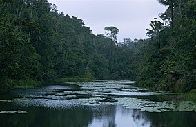
 Analamazaotra National Park, November 1998 | |
| Location | Alaotra-Mangoro, Madagascar |
| Coordinates | 18°56′10″S 48°25′42″E / 18.93611°S 48.42833°E |
| Area | 26.53 km2 (10.24 sq mi) |
| Established | 1970 (special reserve), 21 April 2015 (national park) |
| Governing body | Madagascar National Parks Association |
Analamazaotra National Park is a national park of Madagascar. The park is in the eastern portion of Madagascar's Central Highlands. The neighbouring Analamazaotra Forest Station is a local reforestation effort. It adjoins Andasibe-Mantadia National Park to the north.
The reserve is situated in the region Alaotra-Mangoro, close to Moramanga and Andasibe.[2]
Analamazaotra National Park is located 27 km from Moramanga and is bordered on the south by National road 2, a secondary road to Andasibe and a railway line between Antananarivo and Toamasina.

