Bretenoux
Location of Bretenoux
Map
Bretenoux is located in France
Bretenoux
Bretenoux
Bretenoux is located in Occitanie
Bretenoux
Bretenoux
Coordinates: 44°54′54″N 1°50′21″E / 44.915°N 1.8392°E / 44.915; 1.8392
CountryFrance
RegionOccitania
DepartmentLot
ArrondissementFigeac
CantonCère et Ségala
Government
 • Mayor (2020–2026) Pierre Moles[1]
Area
1
5.69 km2 (2.20 sq mi)
Population
 (2021)[2]
1,389
 • Density240/km2 (630/sq mi)
Time zoneUTC+01:00 (CET)
 • Summer (DST)UTC+02:00 (CEST)
INSEE/Postal code
46038 /46130
Elevation129–245 m (423–804 ft)
(avg. 136 m or 446 ft)
1 French Land Register data, which excludes lakes, ponds, glaciers > 1 km2 (0.386 sq mi or 247 acres) and river estuaries.

Bretenoux (French pronunciation: [bʁətnu]; Occitan: Bertenor) is a commune in the Lot department in southwestern France. The old town, a bastide, is an old medieval town designed with a grid street design with houses dating from 13th to the 16th Century's.

Toponymy

Bretenoux comes from the name Brittanorum villa, which means "the domain, the property, of the Breton villa."[3] The origin of the name may come from the settling of Breton in the area in 5 and 6th Century's AD after they fled their land from Angles and Saxons invaders.[3] Later names used was Villafranca d'Orilenda, Orlanda and Orlinda.[4]

History

The town is first mentioned in the monastery of Beaulieu's cartulary in 866.[5] It was called the Villa Bretenoro.[5]

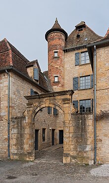
Founded in 1277 by the powerful Guerin, Lord of Castelnau, it has retained its checker-board grid plan, squares and its covered arcades, remains of ramparts, and two beautiful turreted houses, one the town hall, the other the gendarmerie.[5][6]: 307  He granted the town fishing rights, access to the river islands, and two markets a year on condition a wall was constructed around the town with moats and four gates.[5]

Geography

Location

The Bastide is located north of the Lot, near the border with the Corrèze department, in the Dordogne Valley, Bretenoux is attached to the town of Biars-sur-Cère. It is watered by the Cère and Le Mamoul rivers, and crossed by the D940 and D803 national roads.

Demographics

Historical population
YearPop.±% p.a.
1968 1,071—    
1975 1,115+0.58%
1982 1,213+1.21%
1990 1,211−0.02%
1999 1,231+0.18%
2009 1,342+0.87%
2014 1,395+0.78%
2020 1,370−0.30%
Source: INSEE[7]

Local culture and heritage

Places and monuments

Town Hall in Bretenoux

Notable persons

International relations

See also: List of twin towns and sister cities in France

Bretenoux is twinned with Glastonbury, United Kingdom.[8]

See also

References

  1. ^ "Répertoire national des élus: les maires" (in French). data.gouv.fr, Plateforme ouverte des données publiques françaises. 13 September 2022.
  2. ^ "Populations légales 2021". The National Institute of Statistics and Economic Studies. 28 December 2023.
  3. ^ a b Bazalgues, Gaston (2002). À la découverte des noms de lieux du Quercy. Toponymie lotoise (in French). Gourdon: Éditions de la Bouriane et du Quercy. p. 127. ISBN 2-910540-16-2.
  4. ^ Crochet, Bernard (2012). Les plus belles bastides du Sud-Ouest (in French). Internet Archive. Rennes : Ouest-France. p. 78. ISBN 978-2-7373-5222-5.
  5. ^ a b c d e f Chantraine, Colette (17 September 1996). The Lot. Internet Archive. Le Editions du Laquet. p. 25. ISBN 978-2-910333-01-0.
  6. ^ The Green Guide: Dordogne Berry Limousin. Michelin Travel Publication. 2002. ISBN 2060008719.
  7. ^ Population en historique depuis 1968, INSEE
  8. ^ "British towns twinned with French towns [via WaybackMachine.com]". Archant Community Media Ltd. Archived from the original on 5 July 2013. Retrieved 20 July 2013.