Clos du Doubs | |
|---|---|
 Clos du Doubs | |
 Coat of arms | |
Location of Clos du Doubs  | |
| Country | Switzerland |
| Canton | Jura |
| District | Porrentruy |
| Area | |
| • Total | 61.86 km2 (23.88 sq mi) |
| Elevation | 440 m (1,440 ft) |
| Population (31 December 2018)[2] | |
| • Total | 1,286 |
| • Density | 21/km2 (54/sq mi) |
| Time zone | UTC+01:00 (Central European Time) |
| • Summer (DST) | UTC+02:00 (Central European Summer Time) |
| Postal code(s) | 2882 |
| SFOS number | 6808 |
| ISO 3166 code | CH-JU |
| Localities | Epauvillers, Epiquerez, Montenol, Montmelon, Ocourt, Saint-Ursanne and Seleute |
| Surrounded by | Montfaucon, Soubey, Saint-Brais, La Baroche, Glovelier, Boécourt, Cornol, Courgenay, Fontenais, Bressaucourt, Montancy (F), Burnevillers (F) |
| Website | http://www.closdudoubs.ch SFSO statistics |
Clos du Doubs is a municipality in the district of Porrentruy in the canton of Jura in Switzerland. It was founded at January 1, 2009 by the former municipalities of Epauvillers, Epiquerez, Montenol, Montmelon, Ocourt, Saint-Ursanne and Seleute.[3] Soubey voted not to join the merger.
The new town took its name from the Clos du Doubs region (which also includes Soubey). The region includes the section of the Doubs valley near Saint-Ursanne, about 15 km (9.3 mi) west of Delémont. The region covers about 80 km2 (31 sq mi), centered on the village of Saint-Ursanne.
Clos du Doubs can also refer to a range of the Jura folds south-west of Saint-Ursanne.
Geography

Clos du Doubs has an area of 61.75 km2 (23.84 sq mi).[4] Of this area, 26.51 km2 (10.24 sq mi) or 42.9% is used for agricultural purposes, while 32.21 km2 (12.44 sq mi) or 52.1% is forested. Of the rest of the land, 2.24 km2 (0.86 sq mi) or 3.6% is settled (buildings or roads), 0.78 km2 (0.30 sq mi) or 1.3% is either rivers or lakes and 0.08 km2 (20 acres) or 0.1% is unproductive land.[5]
Of the built up area, housing and buildings made up 1.2% and transportation infrastructure made up 2.0%. Out of the forested land, 48.7% of the total land area is heavily forested and 3.4% is covered with orchards or small clusters of trees. Of the agricultural land, 5.7% is used for growing crops and 27.5% is pastures and 9.5% is used for alpine pastures. All the water in the municipality is flowing water.[5]
Demographics

Clos du Doubs has a population (as of December 2020[update]) of 1,263.[6] As of 2010[update], 6.6% of the population are resident foreign nationals.[7] Over the last 10 years (2000–2010) the population has changed at a rate of -2.7%. Migration accounted for -1.5%, while births and deaths accounted for -2%.[8]
Most of the population (as of 2000[update]) speaks French (90.5%) as their first language, German is the second most common (6.0%) and Serbo-Croatian is the third (1.1%). [8]
As of 2008[update], the population was 49.6% male and 50.4% female. The population was made up of 592 Swiss men (46.4% of the population) and 41 (3.2%) non-Swiss men. There were 600 Swiss women (47.0%) and 43 (3.4%) non-Swiss women.[7]
As of 2000[update], children and teenagers (0-19 years old) make up 23.6% of the population, while adults (20-64 years old) make up 55.1% and seniors (over 64 years old) make up 21.2%.[8]
As of 2009[update], the construction rate of new housing units was 3.8 new units per 1000 residents.[8] The vacancy rate for the municipality, in 2010[update], was 1.58%.[8]
Historic Population
The historical population is given in the following chart:[9]
Unable to compile EasyTimeline input:
Timeline generation failed: More than 10 errors found
Line 40: bar:1850 from: 293 till:542 text:"249" color:EQ
- PlotData invalid. Attribute 'color' has unknown color 'eq'.
Specify command 'Color' before this command.
Line 41: bar:1860 from: 291 till:533 text:"242" color:EQ
- PlotData invalid. Attribute 'color' has unknown color 'eq'.
Specify command 'Color' before this command.
Line 42: bar:1870 from: 290 till:575 text:"285" color:EQ
- PlotData invalid. Attribute 'color' has unknown color 'eq'.
Specify command 'Color' before this command.
Line 43: bar:1880 from: 300 till:538 text:"238" color:EQ
- PlotData invalid. Attribute 'color' has unknown color 'eq'.
Specify command 'Color' before this command.
Line 44: bar:1890 from: 320 till:526 text:"206" color:EQ
- PlotData invalid. Attribute 'color' has unknown color 'eq'.
Specify command 'Color' before this command.
Line 45: bar:1900 from: 251 till:437 text:"186" color:EQ
- PlotData invalid. Attribute 'color' has unknown color 'eq'.
Specify command 'Color' before this command.
Line 46: bar:1910 from: 259 till:436 text:"177" color:EQ
- PlotData invalid. Attribute 'color' has unknown color 'eq'.
Specify command 'Color' before this command.
Line 47: bar:1920 from: 258 till:439 text:"181" color:EQ
- PlotData invalid. Attribute 'color' has unknown color 'eq'.
Specify command 'Color' before this command.
Line 48: bar:1930 from: 227 till:341 text:"114" color:EQ
- PlotData invalid. Attribute 'color' has unknown color 'eq'.
Specify command 'Color' before this command.
Line 49: bar:1940 from: 212 till:358 text:"146" color:EQ
- PlotData invalid. Attribute 'color' has unknown color 'eq'.
Specify command 'Color' before this command.
Line 50: bar:1950 from: 196 till:367 text:"171" color:EQ
- PlotData invalid. Attribute 'color' has unknown color 'eq'.
Specify command 'Color' before this command.
Heritage sites of national significance
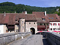
The farm house at Chez Danville 5 in Montmelon, Montvoie Castle, the Saint-Ursanne Collegiate church, the fortifications at Saint-Ursanne, the bridge over the Doubs river, and the medieval village of Saint-Ursanne are listed as Swiss heritage site of national significance. The entire village of Saint-Ursanne and the hamlet of Montenol are part of the Inventory of Swiss Heritage Sites.[10]
-

-
 Saint-Ursanne Collegiate church
 -
 Bridge over the Doubs
 -
 name= Saint-Ursanne, Medieval Village


Economy
As of 2010[update], Clos du Doubs had an unemployment rate of 2.9%. As of 2008[update], there were 227 people employed in the primary economic sector and about 74 businesses involved in this sector. 173 people were employed in the secondary sector and there were 12 businesses in this sector. 349 people were employed in the tertiary sector, with 46 businesses in this sector.[8]
Of the working population, 9% used public transportation to get to work, and 47.9% used a private car.[8]
Education
The Canton of Jura school system provides two year of non-obligatory Kindergarten, followed by six years of Primary school. This is followed by three years of obligatory lower Secondary school where the students are separated according to ability and aptitude. Following the lower Secondary students may attend a three or four year optional upper Secondary school followed by some form of Tertiary school or they may enter an apprenticeship.[11]
During the 2009-10 school year, there were a total of 100 students attending 7 classes in Clos du Doubs. There was one kindergarten class with a total of 16 students in the municipality.[12] The municipality had 6 primary classes and 84 students.[13] There are only nine Secondary schools in the canton, so all the students from Clos du Doubs attend their secondary school in another municipality.
References
- ^ a b "Arealstatistik Standard - Gemeinden nach 4 Hauptbereichen". Federal Statistical Office. Retrieved 13 January 2019.
- ^ "Ständige Wohnbevölkerung nach Staatsangehörigkeitskategorie Geschlecht und Gemeinde; Provisorische Jahresergebnisse; 2018". Federal Statistical Office. 9 April 2019. Retrieved 11 April 2019.
- ^ Amtliches Gemeindeverzeichnis der Schweiz published by the Swiss Federal Statistical Office Template:De icon accessed 19 July 2011
- ^ Arealstatistik Standard - Gemeindedaten nach 4 Hauptbereichen
- ^ a b Swiss Federal Statistical Office-Land Use Statistics 2009 data Template:De icon accessed 25 March 2010
- ^ "Ständige und nichtständige Wohnbevölkerung nach institutionellen Gliederungen, Geburtsort und Staatsangehörigkeit". bfs.admin.ch (in German). Swiss Federal Statistical Office - STAT-TAB. 31 December 2020. Retrieved 21 September 2021.
- ^ a b Population résidante permanente des communes, selon le sexe et la nationalité, au 31 décembre 2010, canton du Jura pdf document from the Canton of Jura Statistical Office accessed 19 December 2011
- ^ a b c d e f g Swiss Federal Statistical Office accessed 29-December-2011
- ^ Federal Statistical Office STAT-TAB Bevölkerungsentwicklung nach Region, 1850-2000 Template:De icon accessed 29 January 2011
- ^ "Kantonsliste A-Objekte". KGS Inventar (in German). Federal Office of Civil Protection. 2009. Retrieved 25 April 2011.
((cite web)): External link in|work= - ^ EDK/CDIP/IDES (2010). Kantonale Schulstrukturen in der Schweiz und im Fürstentum Liechtenstein / Structures Scolaires Cantonales en Suisse et Dans la Principauté du Liechtenstein (PDF) (Report). Retrieved 24 June 2010.
- ^ Effectifs de l'école enfantine 2009-2010 Template:Fr icon accessed 19 December 2011
- ^ Effectifs de l'école primaire Template:Fr icon accessed 19 December 2011
Municipalities in Porrentruy District, Switzerland | ||
|---|---|---|