Fairfield Plantation, Georgia | |
|---|---|
 Fairfield Plantation  Fairfield Plantation | |
| Coordinates: 33°38′37″N 84°55′33″W / 33.64361°N 84.92583°W | |
| Country | |
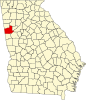
| State | Georgia |
| County | Carroll |
| Area | |
| • Total | 4.51 sq mi (11.69 km2) |
| • Land | 4.11 sq mi (10.65 km2) |
| • Water | 0.40 sq mi (1.03 km2) |
| Elevation | 1,140 ft (350 m) |
| Population (2020) | |
| • Total | 4,898 |
| • Density | 1,190.57/sq mi (459.73/km2) |
| Time zone | UTC-5 (Eastern (EST)) |
| • Summer (DST) | UTC-4 (EDT) |
| ZIP Code | 30180 (Villa Rica) |
| Area code(s) | 770/678/470 |
| FIPS code | 13-28440 |
| GNIS feature ID | 2812672[2] |
Fairfield Plantation is an unincorporated community and census-designated place in eastern Carroll County, Georgia, United States. It is a community situated around a golf course and reservoir (Treasure Lake), 8 miles (13 km) south of Villa Rica and 38 miles (61 km) west of Atlanta. Fairfield Plantation was created as a Planned Unit Development in the 1970s. The population as of the 2020 census is 4,898.[3]
The community was first listed as a CDP prior to the 2020 census.