.svg)

The geography of the State of Hidalgo refers to the physical geography and human geography of Hidalgo, a state in central Mexico.
It's located in the region east of the country, bordering to the north with San Luis Potosí and Veracruz, to the east with Puebla, to the south with Tlaxcala and the state of Mexico, and to[1] It's located between the coordinates: to the north, 21°23′55″; to the south, 19°35′52″ of the latitude north; to the east, 97°59′06″; to the west, [clarification needed].[. 1] It's made up of eighty-four municipalities.[2]
According to INEGI, it has an area of 20 813.57 km2,[3] and represents 1.06% of the area of the country.[note 1][1][5] It's the 6th least extensive state - ahead of Querétaro, Colima, Aguascalientes, Morelos and Tlaxcala, the least extensive. The largest municipality is Zimapán, with an area of 872.24 km2 representing 4.19% of the state area;[note 2] And the least extensive municipality is Tlahuelilpan, with an area of 28.18 km2 representing 0.14% of the state area.[note 3][3][10]
Geographical regions
[edit]Characteristics
[edit]
The state of Hidalgo shows a great geographical diversity, which causes the existence of an extensive variety of flora and fauna, as well as climatic and geomorphological conditions.[. 2] From north to south, there are three clear regions: the first is the Northern Gulf Coastal Plain, and the one with the lowest altitude; the second is composed of the Eastern Mother Sierra, with medium altitude, and the third is the Neovolcanic Axis, with the highest altitude in the state.[11]
So different and contrasting between one region and another that they directly affect the economic aspects and way of life of its inhabitants; this has made it possible to classify and identify ten natural regions that group municipalities with similar characteristics.[. 2] The geocultural regions of Hidalgo constitute an exercise in the grouping of geographical spaces based on the cultural characteristics they share.[12]
In this way, in the northwestern portion of the state, the Huasteca region has been fully identified.[. 2] In the part corresponding to the Sierra Madre Oriental, located in the center of the territory, with a southeast–northwest direction, municipalities are grouped into four different regions: Sierra de Tenango, Sierra Baja, Sierra Alta, and Sierra Gorda. In the Neovolcanic Axis, in the center is the Mining Valley, in the southeast fraction is the Tulancingo Valley and the Altiplanicie pulquera, to the west and southwest the Mezquital Valley, to the south is the Cuenca de México.<refname />
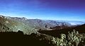
The Huasteca is a long and narrow strip of abundant vegetation, it has a little rugged surface, except for some peaks and hills it lacks remarkable mountains.[. 3] La Sierra Alta es una región en donde destacan bruscas elevaciones que forman parte de la Sierra Madre Oriental.[. 3] In the Sierra Baja its landscape is not precisely of high hills or sharp mountains, but of a plain that suddenly seems to sink through its barrancas and canñones.[. 3]
The Sierra Gorda was born in Hidalgo as a branch of the Sierra Madre Oriental, in this part there are very rugged surfaces with rough and boluda mountains.[. 3] The Sierra de Tenango also called Sierra Otomí-Tepehua is a region of less abrupt mountains and has small intramontaneous plain.[. 3] The Tulancingo Valley in a large valley that could formerly be a basin Lakester, begins where the mountain ends its conformation, is characterized by the presence of some rock formations of volcanic origin.[. 4][13] The Mining Region has a relief of serranía is an area rich in deposits of metals such as lead, gold and silver.[11]
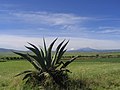
The Altiplanicie pulquera also known as the plains of Apan, is an Highland with three lake areas, small the so-called lagoons of Tochac-Atocha, Apan[14] it has cultivation landscapes, especially the maguey pulque.[11] The Basin of Mexico also called Pachuca-Tizayuca Valley corresponds to semi-arid plains that are highly usable for agricultural activities,[. 4] it's a corridor protected by a chain of hills on each side.[11] The Mezquital Valley is made up of various valleys and plains, limited by isolated volcanic mountains and basaltic spills;[11] it includes a surface of extreme aridity.[. 4]
Delimitation
[edit]The number of regions that make up the state of Hidalgo depends on the work and the author consulted. Sometimes the Sierra Alta and the Sierra Baja are placed in a single region called the Sierra Hidalguense.[15][. 5][. 6][. 7] and to the Tulancingo Valley, the Mining Region, the Altiplanicie pulquera, the Basin of Mexico; they are placed in a single region called the Altiplano Hidalguense.[. 4][. 8][. 9] The Sierra de Tenango, is confused with the slopes that go down to the Huasteca;[11] some geographical letters name it as part of the Sierra Norte de Puebla and others as part of the Sierra de Huayacocotla.[11] Even the Acaxochitlán is named as part of the Totonacapan region.[16][17][18]
The Huasteca is a multicultural region that includes the southern part of the state of Tamaulipas, the north of Veracruz, the east of San Luis Potosí, the north of the state of Hidalgo, a northern portion of Querétaro.[19] The Huasteca Hidalgo, is located to the north of the state territory, but some sources extend it to the south, to the municipalities of Molango de Escamilla, Metztitlán and Zacualtipán de Ángeles.[20][16] Even annexing parts of the municipality of Huasca de Ocampo,[21] And the Sierra de Tenango,[20][16] reaching the northern part of Puebla.[19]
The Basin of Mexico was an endorheic basin formed by a large system of lakes: Chalco, Xochimilco, Texcoco, San Cristóbal-Xaltocan.[22] The region is made up of four valleys, the Valley of Mexico, Valley of Cuautitlán, Valley of Apan and the Pachuca-Tizayuca Valley; it's comprised between four federal entities: the state of Mexico, Mexico City, Hidalgo and Tlaxcala. The Sierra Gorda is born in Hidalgo as a branch of the Sierra Madre Oriental and culminates in San Luis Potosí, after crossing Querétaro and Guanajuato.[. 3] The Mezquital Valley can extend to the northern part of the state of Mexico and a limited area of the southeast of the state of Querétaro.[23][24]
-
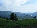
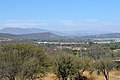
 Municipality of Apan in the Valley of Apan.
 -
 Municipality of Mineral del Chico in the Mining Mine.
 -
-
-
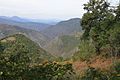
 Tlanchinol in the Sierra Alta.
 -
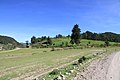
 Municipality of Juárez, Hidalgo in the Sierra Baja.
 -
 Municipality of San Bartolo Tutotepec in the Sierra de Tenango.
 -
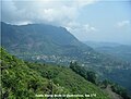
 Municipality of Zimapán in the Sierra Gorda.
 -
 Cuautepec de Hinojosa in the Tulancingo Valley.
 -
 Tula de Allende in the Mezquital Valley.


.jpg)


Climatology
[edit]Climate
[edit]
Geographically, three well-defined climatic zones are distinguished in the state of Hidalgo: zone of warm and semi-warm climates, zone of temperate climates, and Zone of dry and semi-dry climates.[. 10][25][26] To a lesser extent, the semi-cold climate appears in small areas, which develops in the highest parts of the state.[. 10][26]
| Average annual climate parameters of Hidalgo (1951–2010). | ||||||
|---|---|---|---|---|---|---|
| Stational Lap | Municipality | Altitude (m. s. n. m.) |
Temperature (°C) | Precipitación (mm) | ||
| Minimum (average) |
Media |
Maximum (average) | ||||
| 00013011 | Huejutla de Reyes | 150.0 | 17.3 | 23.7 | 30.1 | 1469.7 |
| 00013038 | Tlanchinol | 1365.0 | 13.4 | 17.6 | 21.8 | 2416.2 |
| 00013034 | Tenango de Doria | 1666.0 | 11.6 | 17.0 | 22.5 | 1733.7 |
| 00013074 | Ixmiquilpan | 1700.0 | 8.8 | 17.7 | 26.6 | 342.4 |
| 00013050 | Zacualtipán de Ángeles | 1980.0 | 8.5 | 13.6 | 18.8 | 1287.3 |
| 00013056 | Pachuca de Soto | 2368.0 | 6.6 | 14.0 | 21.4 | 411.9 |
| 00013115 | Mineral del Monte | 2812.0 | 7.5 | 13.0 | 18.5 | 870.7 |
| Fuente: Servicio Meteorológico Nacional.[27][28][29][30][31][32][33] | ||||||

See also
[edit]References
[edit]Notes
[edit]- ^ INEGI 2017, p. 19
- ^ a b c INEGI 2004, p. 5
- ^ a b c d e f INEGI 2004, p. 6
- ^ a b c d INEGI 2004, p. 7
- ^ Ballesteros García & Cuatepotzo Costeira 2003, p. 15
- ^ Ballesteros García & Cuatepotzo Costeira 2003, p. 16
- ^ González Olguín, Mera Mendoza & Reyes Olvera 1994, p. 28
- ^ Ballesteros García & Cuatepotzo Costeira 2003, p. 18
- ^ González Olguín, Mera Mendoza & Reyes Olvera 1994, p. 41
- ^ a b INEGI 1992, p. 9
- ^ According to the Government of Hidalgo its area is 20,987 km2.[4]
- ^ According to the Government of Hidalgo its area is 860.9 km2;[4][6] and according to the SEDESOL it is 874,682 km2.[7]
- ^ According to the Government of Hidalgo its area is 31.3 km2;[4] according to the INAFED is 28.60 km2;[8] and according to the SEDESOL it is 28,265 km2.[9]
Citations
[edit]- ^ a b Instituto Nacional para el Federalismo y el Desarrollo Municipal (2010). "Encyclopedia of the Municipalities and Delegations of Mexico: Physical environment of the state of Hidalgo". Secretariat of the Interior. Government of Mexico. Archived from the original on 29 November 2016. Retrieved 20 March 2018.
- ^ INEGI. "Hidalgo Municipal Division". Tell me about Mexico. Retrieved July 20, 2010.
- ^ a b National Institute for Federalism and Municipal Development. "National Municipal Information System". Secretariat of the Interior. Gobierno de México. Retrieved March 20, 2018. To see information about Hidalgo, first select the type of information you want, then the state of Hidalgo in the "Federative Entity" field.
- ^ a b c COESPO (2015). "Hidalgo. Total population and population density by municipality, 2015" (PDF). State Population Council. Archived from the original (PDF) on February 22, 2017. Retrieved March 25, 2018.
- ^ INEGI. "Area of Hidalgo". Tell me about Mexico. Retrieved July 20, 2010.
- ^ National Institute for Federalism and Municipal Development (2010). "Encyclopedia of the Municipalities and Delegations of Mexico: Zimapán, Hidalgo". Ministry of the Interior. Archived from the original on March 28, 2018. Retrieved March 20, 2018.
- ^ Municipal Information Cards. "Zimapán, Hidalgo". Secretariat of Social Development. Archived from the original on September 29, 2017. Retrieved March 20, 2018.
- ^ National Institute for Federalism and Municipal Development (2010). "Encyclopedia of the Municipalities and Delegations of Mexico: Tlahuelilpan, Hidalgo". Ministry of the Interior. Archived from the original on February 3, 2019. Retrieved March 20, 2018.
- ^ Municipal Information Cards. "Tlahuelilpan, Hidalgo". Secretariat of Social Development. Archived from the original on September 29, 2017. Retrieved March 22, 2017.
- ^ INEGI. "Hidalgo" (PDF). Municipal geographic information record of the United Mexican States. National Institute of Statistics and Geography. Retrieved March 22, 2017.
- ^ a b c d e f g Instituto Nacional para el Federalismo y el Desarrollo Municipal (2010). "Enciclopedia de los Municipios y Delegaciones de México: Regionalización del estado de Hidalgo". Secretaría de Gobernación. Gobierno de México. Archived from the original on 18 January 2017. Retrieved 20 March 2018.
- ^ "Regiones Geoculturales del Estado de Hidalgo". Secretaría de Cultura del Estado de Hidalgo. Gobierno del Estado de Hidalgo. 2019. Archived from the original on 23 February 2020. Retrieved 23 February 2020.
- ^ Pacheco Medina, María Esther (22 September 2019). "El Valle de Tulancingo". Periódico El Independiente de Hidalgo. Archived from the original on 8 October 2020. Retrieved 23 February 2020.
- ^ Legorreta, Jorge (2013). "Los ríos de la Ciudad de México: pasado, presente y futuro". Ciencias. 18 (32). Universidad Nacional Autónoma de México: 107–108. ISSN 0187-6376. Archived from the original on 23 February 2020. Retrieved 14 February 2020.
- ^ Redacción (18 April 2018). "Lo delicioso de la Sierra Hidalguense". Periódico Criterio de Hidalgo. Retrieved 23 February 2020.
- ^ a b c Serrano Carreto, Enrique [Coordinador] (2006). Regiones indígenas de México (PDF) (Primera ed.). Delegación Álvaro Obregón, Ciudad de México: Comisión Nacional para el Desarrollo de los Pueblos Indígenas, Programa de las Naciones Unidas para el Desarrollo. pp. 42–47. Retrieved 3 September 2019.
- ^ INAH. "El totonacapan". Instituto Nacional de Antropología e Historia. Archived from the original on 2 April 2018. Retrieved 2 April 2018.
- ^ Zúñiga Bravo, Federico Gerardo (2014). "Las transformaciones del territorio y el patrimonio cultural en el Totonacapan veracruzano, México, basadas en la actividad turística como estrategia de desarrollo regional". Cuadernos de Turismo (34). Murcia, España: Universidad de Murcia: 351–372. ISSN 1139-7861. Retrieved 2 April 2018.
- ^ a b INAH (14 July 2008). "La Huasteca: región multicultural". National Institute of Anthropology and History. Archived from the original on 2 December 2021. Retrieved 23 February 2020.
- ^ a b "La Huasteca: región multicultural". Instituto Nacional de Antropología e Historia. 14 July 2008. Archived from the original on 2 December 2021. Retrieved 3 September 2019.
- ^ Sagaón Velázquez, José Nabor (19 September 2012). "Territorio Huasteco". Escuela Normal de Las Huastecas. Retrieved 3 September 2019.
- ^ Dirección General de Divulgación de la Ciencia (30 May 2016). "a historia hidrológica de la Cuenca de México". Fundación UNAM. Retrieved 23 February 2020.
- ^ López Aguilar, Fernando (1997). "Las distinciones y las diferencias en la historia colonial del Valle del Mezquital" (PDF). Dimensión Antropológica. 9–10 (4). Ciudad de México, México: Instituto Nacional de Antropología e Historia: 27–70. ISSN 1405-776X.
- ^ López Aguilar, Fernando (2015). "El paleoclima y el paleopaisaje del valle del Mezquital. Una lectura múltiple". Cambio climático Índice y procesos culturales Vol. 2. Ciudad de México, México: Academia Mexicana de Ciencias Antropológicas: 75–133. Archived from the original (PDF) on 2022-05-27. Retrieved 2024-01-06.
- ^ SAGARPA (2010). "Resultados del Estudio del Diagnóstico del Sector Agropecuario en el estado de Hidalgo" (PDF). Secretaría de Agricultura, Ganadería, Desarrollo Rural, Pesca y Alimentación. Gobierno de Mexico. Archived from the original (PDF) on 12 March 2017. Retrieved 27 December 2015.
- ^ a b Instituto Nacional de Investigaciones Forestales, Agrícolas y Pecuarias. "Datos climatologícos de Hidalgo". Secretaría de Agricultura, Ganadería, Desarrollo Rural, Pesca y Alimentación. Gobierno de Mexico. Archived from the original on 23 April 2018. Retrieved 16 April 2018.
- ^ Comisión Nacional del Agua (2010). "Servicio Meteorológico Nacional: Normales Climatológicas de Huejutla". Secretaría de Medio Ambiente y Recursos Naturales. Gobierno de México. Archived from the original on 12 March 2017. Retrieved 30 August 2012.
- ^ Comisión Nacional del Agua (2010). "Servicio Meteorológico Nacional: Normales Climatológicas de Tlanchinol". Secretaría de Medio Ambiente y Recursos Naturales. Gobierno de México. Retrieved 30 August 2012.
- ^ Comisión Nacional del Agua (2010). "Servicio Meteorológico Nacional: Normales Climatológicas de Tenango de Doria". Secretaría de Medio Ambiente y Recursos Naturales. Gobierno de México. Archived from the original on 12 March 2017. Retrieved 30 August 2012.
- ^ Comisión Nacional del Agua (2010). "Servicio Meteorológico Nacional: Normales Climatológicas de Ixmiquilpan". Secretaría de Medio Ambiente y Recursos Naturales. Gobierno de México. Retrieved 30 August 2012.
- ^ Comisión Nacional del Agua (2010). "Servicio Meteorológico Nacional: Normales Climatológicas de Zacualtipán". Secretaría de Medio Ambiente y Recursos Naturales. Gobierno de México. Retrieved 30 August 2012.
- ^ Comisión Nacional del Agua (2010). "Servicio Meteorológico Nacional: Normales Climatológicas de Pachuca". Secretaría de Medio Ambiente y Recursos Naturales. Gobierno de México. Retrieved 30 August 2012.
- ^ Comisión Nacional del Agua (2010). "Servicio Meteorológico Nacional: Normales Climatológicas de Real del Monte". Secretaría de Medio Ambiente y Recursos Naturales. Gobierno de México. Retrieved 30 August 2012.
Sources
[edit]- Ballesteros García, Víctor Manuel; Cuatepotzo Costeira, Miguel Ángel (2003). Canto de Sol, Hidalgo; Tierra, historia y gente. Pachuca, Hidalgo: Sistema de Educación Pública del Estado de Hidalgo. ISBN 968-751-721-2.
- González Olguín, Miguel Ángel; Mera Mendoza, Oswaldo; Reyes Olvera, Juan (1994). Hidalgo: Historia y Geografía, tercer grado (Primera ed.). México, D.F.: Secretaría de Educación Pública. ISBN 968-296-015-0.
- INEGI (1992). Síntesis geográfica del estado de Hidalgo (Primera ed.). Aguascalientes, Aguascalientes: Instituto Nacional de Estadística y Geografía. ISBN 968-892-735-X. Archived from the original (PDF) on 2 April 2018. Retrieved 2 April 2018.
- INEGI (2004). Hidalgo Hoy (Primera ed.). Aguascalientes, Aguascalientes: Instituto Nacional de Estadística y Geografía. ISBN 970-13-4477-4.
- INEGI (2017). Anuario estadístico y geográfico de Hidalgo, edición 2017 (PDF) (Primera ed.). Aguascalientes, Aguascalientes: Instituto Nacional de Estadística y Geografía.