Loring Colony, Montana | |
|---|---|
 Loring Colony  Loring Colony | |
| Coordinates: 48°47′21″N 107°58′07″W / 48.78917°N 107.96861°W | |
| Country | United States |
| State | Montana |
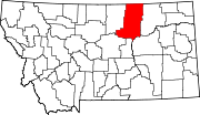
| County | Phillips |
| Area | |
| • Total | 0.37 sq mi (0.96 km2) |
| • Land | 0.37 sq mi (0.96 km2) |
| • Water | 0.00 sq mi (0.00 km2) |
| Elevation | 2,841 ft (866 m) |
| Population (2020) | |
| • Total | 48 |
| • Density | 129.38/sq mi (49.94/km2) |
| Time zone | UTC-7 (Mountain (MST)) |
| • Summer (DST) | UTC-6 (MDT) |
| ZIP Code | 59537 (Loring) |
| Area code | 406 |
| FIPS code | 30-45179 |
| GNIS feature ID | 2804315[2] |
Loring Colony is a Hutterite community[3] and census-designated place (CDP) in Phillips County, Montana, United States. It is in the northwest part of the county, 7 miles (11 km) west of U.S. Route 191, less than one mile south of US-191 passes through the small unincorporated community of Loring. Via US-191, Loring Colony is 44 miles (71 km) north of Malta, the Phillips county seat.
The community was first listed as a CDP prior to the 2020 census.[2]