Lucerne, Kansas | |
|---|---|
 | |
 Lucerne  Lucerne | |
| Coordinates: 39°29′48″N 100°12′01″W / 39.49667°N 100.20028°W | |
| Country | United States |
| State | Kansas |
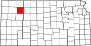
| County | Sheridan |
| Township | Adell |
| Elevation | 2,648 ft (807 m) |
| Population | |
| • Total | 0 |
| Time zone | UTC-6 (CST) |
| • Summer (DST) | UTC-5 (CDT) |
| Area code | 785 |
| GNIS ID | 484550[1] |
Lucerne is a ghost town in Adell Township, Sheridan County, Kansas, United States. It is approximately 18 miles northeast of the county seat of Hoxie.