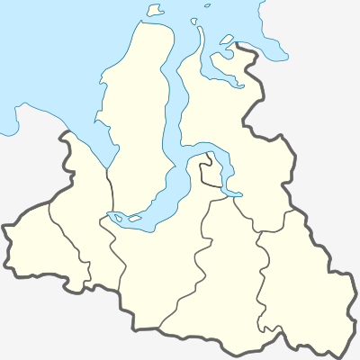
| This is a documentation subpage for Module:Location map/data/Russia Yamalo-Nenets Autonomous Okrug. It may contain usage information, categories and other content that is not part of the original module page. |
| name | Yamalo-Nenets Autonomous Okrug | |||
|---|---|---|---|---|
| border coordinates | ||||
| 73.52 | ||||
| 62.02 | ←↕→ | 85.55 | ||
| 62.47 | ||||
| map center | 67°59′42″N 73°47′06″E / 67.995°N 73.785°E | |||
| image | Yamalo-Nenetsky AO.svg
| |||

| ||||
Module:Location map/data/Russia Yamalo-Nenets Autonomous Okrug is a location map definition used to overlay markers and labels on an equirectangular projection map of Yamalo-Nenets Autonomous Okrug. The markers are placed by latitude and longitude coordinates on the default map or a similar map image.
Usage
These definitions are used by the following templates when invoked with parameter "Russia Yamalo-Nenets Autonomous Okrug":
((Location map|Russia Yamalo-Nenets Autonomous Okrug |...))((Location map many|Russia Yamalo-Nenets Autonomous Okrug |...))((Location map+|Russia Yamalo-Nenets Autonomous Okrug |...))((Location map~|Russia Yamalo-Nenets Autonomous Okrug |...))
Map definition
name = Yamalo-Nenets Autonomous Okrug- Name used in the default map caption
image = Yamalo-Nenetsky AO.svg- The default map image, without "Image:" or "File:"
top = 73.52- Latitude at top edge of map, in decimal degrees
bottom = 62.47- Latitude at bottom edge of map, in decimal degrees
left = 62.02- Longitude at left edge of map, in decimal degrees
right = 85.55- Longitude at right edge of map, in decimal degrees
Precision
Longitude: from West to East this map definition covers 23.53 degrees.
- At an image width of 200 pixels, that is 0.1177 degrees per pixel.
- At an image width of 1000 pixels, that is 0.0235 degrees per pixel.
Latitude: from North to South this map definition covers 11.05 degrees.
- At an image height of 200 pixels, that is 0.0553 degrees per pixel.
- At an image height of 1000 pixels, that is 0.0111 degrees per pixel.
See also
Location map templates
- Template:Location map, to display one mark and label using latitude and longitude
- Template:Location map many, to display up to nine marks and labels
- Template:Location map+, to display an unlimited number of marks and labels