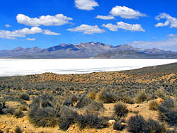
San Juan de Tarucani
Tarujani
Lake Salinas, Tarucani District
Country Peru
RegionArequipa
ProvinceArequipa
FoundedJune 15, 1962
CapitalTarucani
Government
 • MayorFloro Choque Vilca
Area
 • Total2,264.59 km2 (874.36 sq mi)
Elevation
4,210 m (13,810 ft)
Population
 • Total2,296
 • Density1.0/km2 (2.6/sq mi)
Time zoneUTC-5 (PET)
UBIGEO040119

San Juan de Tarucani District (Aymara Tarujani, taruja deer,[1] -ni a suffix, "the one with deer") is one of 29 districts of the province Arequipa in Peru.[2]

Geography

The highest elevation of the district is the Misti volcano at 5,822 m (19,101 ft). Other mountains are listed below:[3]

See also

References

  1. ^ Radio San Gabriel, "Instituto Radiofonico de Promoción Aymara" (IRPA) 1993, Republicado por Instituto de las Lenguas y Literaturas Andinas-Amazónicas (ILLLA-A) 2011, Transcripción del Vocabulario de la Lengua Aymara, P. Ludovico Bertonio 1612 (Spanish-Aymara-Aymara-Spanish dictionary)
  2. ^ (in Spanish) Instituto Nacional de Estadística e Informática. Banco de Información Distrital Archived 2008-04-23 at the Wayback Machine. Retrieved April 11, 2008.
  3. ^ escale.minedu.gob.pe - UGEL map of the General Sánchez Cerro (Moquegua Region)


16°10′59″S 71°04′01″W / 16.18306°S 71.06694°W / -16.18306; -71.06694