This article relies largely or entirely on a single source. Relevant discussion may be found on the talk page. Please help improve this article by introducing citations to additional sources.Find sources: "Serebryany Bor" park – news · newspapers · books · scholar · JSTOR (April 2019)
.mw-parser-output .hidden-begin{box-sizing:border-box;width:100%;padding:5px;border:none;font-size:95%}.mw-parser-output .hidden-title{font-weight:bold;line-height:1.6;text-align:left}.mw-parser-output .hidden-content{text-align:left}You can help expand this article with text translated from the corresponding article in Russian. (February 2018) Click [show] for important translation instructions.
Machine translation, like DeepL or Google Translate, is a useful starting point for translations, but translators must revise errors as necessary and confirm that the translation is accurate, rather than simply copy-pasting machine-translated text into the English Wikipedia.
Consider adding a topic to this template: there are already 2,086 articles in the main category, and specifying|topic= will aid in categorization.
Do not translate text that appears unreliable or low-quality. If possible, verify the text with references provided in the foreign-language article.
You must provide copyright attribution in the edit summary accompanying your translation by providing an interlanguage link to the source of your translation. A model attribution edit summary is Content in this edit is translated from the existing Russian Wikipedia article at [[:ru:Серебряный Бор]]; see its history for attribution.
You should also add the template ((Translated|ru|Серебряный Бор)) to the talk page.
For more guidance, see Wikipedia:Translation.
| Serebryany Bor | |
|---|---|
| Серебряный Бор | |
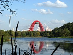
 Serebryany Bor with a view of the Zhivopisny Bridge, 2008 | |
 Location in Moscow | |
| Location | Moscow, Russia |
| Coordinates | 55°46′50″N 37°24′58″E / 55.78056°N 37.41611°E |
| Area | 328.6 hectares[1] |
| Created | October 17, 1991 |
| Public transit access | |
Serebryany Bor (Russian: Серебряный Бор, literally "Silver Pinewood") is a large forest park in north-west Moscow. The park is a natural monument of regional significance and a protected area of the city of Moscow. It poses an artificial island that was formed during the creation of the Khoroshevskoye spryamlenie canal ("Khoroshevsky cutoff" canal).[2] Serebryany Bor covers an area of 328.6 hectares.[1]
It is also a concentration of luxury real estate owned by wealthy businessmen and government officials.[3]