This special page shows all files uploaded to the English Wikipedia. (See also the list for Wikimedia Commons.) By default, the last uploaded files are shown at top of the list, but clicking on a column header will change the sorting.
Deleted files are not shown here but are included in the upload log.
| Date | Name | Thumbnail | Size | Description |
|---|---|---|---|---|
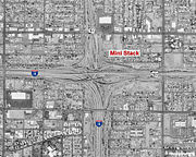
| 04:43, 5 February 2008 | Mini Stack Phoenix.jpg (file) |  |
674 KB | ((Information |Description= |Source=The Mini Stack interchange complex. Underlying map is an aerial map obtained from the USGS The overlying work (freeway number shields, city labels, etc.) are by me. |Date= February 4, 2008 |Location= United States |Auth |
| 03:23, 2 December 2007 | Los Alamitos Curve 405,605,22.png (file) |  |
1.82 MB | The Los Alamitos Curve interchange complex. Underlying map is an aerial map obtained from the USGS The overlying work (freeway number shields, city labels, etc.) are by me. |
| 03:00, 2 December 2007 | Glendora Curve 210,57.png (file) |  |
1.79 MB | The Glendora Curve interchange complex. Underlying map is an aerial map obtained from the USGS The overlying work (freeway number shields, city labels, etc.) are by me. |
| 02:58, 2 January 2006 | Interstate10archibald SPUI.jpg (file) |  |
1.23 MB | An example of a typical Single Point Urban Interchange (SPUI) located at the interchange of the San Bernardino Freeway (Interstate 10) and Archibald Avenue in Ontario, California. Aerial photo obtained from the USGS |
| 01:38, 18 December 2005 | Pradodam.jpg (file) |  |
485 KB | Revised aerial photo/map of the Prado Dam vicinity. I erroneosly labeled YORBA Linda as LOMA Linda in the previous map. The underlying map is an aerial map obtained from the USGS The overlying work (freeway number shields, city labels, etc.) are by me (( |
| 01:59, 12 November 2005 | Fwynet overlaid on pe.jpg (file) |  |
1.58 MB | Map of the Metropolitan Los Angeles freeway network overlaid on the map of the historic Pacific Electric Rail network. The overlying map is by me, the underlying map is in the public domain. |
| 02:33, 23 October 2005 | Diamondbarcrunch.jpg (file) |  |
532 KB | The Diamond Bar Crunch interchange. Underlying map is an aerial map obtained from the USGS The overlying work (freeway number shields, city labels, etc.) are by me. ((PD)) |