This article does not cite any sources. Please help improve this article by adding citations to reliable sources. Unsourced material may be challenged and removed.Find sources: "Waldviertel" – news · newspapers · books · scholar · JSTOR (March 2021) (Learn how and when to remove this template message)
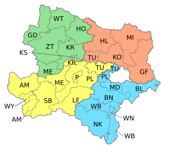
| Quarters and districts of Lower Austria |
|---|
The Waldviertel (German: [ˈvaltˌfɪʁtl̩] ⓘlit. 'Forest Quarter'; Central Bavarian: Woidviadl; Czech: Lesní čtrvť) is the northwestern region of the northeast Austrian state of Lower Austria. It is bounded to the south by the Danube, to the southwest by Upper Austria, to the northwest and the north by the Czech Republic and to the east by the Manhartsberg (537 m, 1,762 ft), which is the survey point dividing Waldviertel from Weinviertel. Geologically it is a part of the Bohemian Massif. In the south are the Wachau and Kamptal wine regions.
