| Wardell New South Wales | |||||||||
|---|---|---|---|---|---|---|---|---|---|
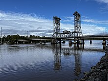
 The lift span bridge over the Richmond River at Wardell. | |||||||||
| Coordinates | 28°57′0″S 153°28′0″E / 28.95000°S 153.46667°E | ||||||||
| Population | 662 (2021 census)[1] | ||||||||
| Established | 1856 | ||||||||
| Postcode(s) | 2477 | ||||||||
| Elevation | 8 m (26 ft) | ||||||||
| Location | |||||||||
| LGA(s) | Ballina Shire | ||||||||
| County | Rous | ||||||||
| State electorate(s) | Ballina | ||||||||
| Federal division(s) | Page | ||||||||
| |||||||||

Wardell is a village in the Northern Rivers region of New South Wales, Australia. It is situated on the Richmond River and the Pacific Highway between Broadwater and Ballina. Wardell is approximately 724 km (450 mi) north of Sydney and 200 km (124 mi) south of Brisbane. The boundaries are within the Ballina Shire local government area.[citation needed]
Population
[edit]| Year | Pop. | ±% |
|---|---|---|
| 1976 | 245 | — |
| 1981 | 295 | +20.4% |
| 1986 | 315 | +6.8% |
| 1991 | 425 | +34.9% |
| 1996 | 450 | +5.9% |
| 2001 | 485 | +7.8% |
| 2006 | 621 | +28.0% |
| 2011 | 648 | +4.3% |
| 2016 | 663 | +2.3% |
| 2021 | 662 | −0.2% |
| Source: Australian Bureau of Statistics data.[2][3] | ||
Wardell had a population of 662 in the 2021 Census: 50.7% were males and 49.3% were females. Of the total population in Wardell 10.1% were Indigenous persons. The most common occupations for employed persons were: technicians and trades workers at 20.4%, labourers 17.8%, community and personal service workers 13.7%, managers 10.2% and professionals 9.9%.[1]
History
[edit]Bingall Creek was an old name of Wardell and it was also known in the 1850s as the cedar-getter's settlement, Blackwall which was established as a river port on the Richmond River. The river was an important transport route for the region for the first 100 years after settlement. It developed into an important sawmilling centre for the timber industry and later for the milling of sugar cane. Wardell is now split by the Pacific Highway and the River and is known by its landmark lift span bridge which was built to replace the ferries and barges used to transport Australian red cedar (Toona ciliata) and sugar cane in the 1800s.[4] A steamboat service from Ballina to Lismore operated for many years. Today Wardell has a general store, post office, pub, service station and the Wardell Public School which has 50 pupils enrolled.[citation needed]
The river and its estuaries abound with marine wildlife and are used for recreational fishing and water sports.[citation needed]
Wardell was the birthplace of architect Alexander Stewart Jolly (1887–1957), who designed a number of buildings in the north coast area. He also designed a number of homes in the Sydney area, some of which are heritage-listed. Poet and painter Edwin Wilson (b. 1942) spent his first six years in a farm house at East Wardell (as recorded in 'The Mullumbimby Kid').[citation needed]
Natural Disaster
[edit]Wardell Flooding Event (February / March 2022)
The flooding event of 2022 was part of the much wider and significant natural disaster that occurred in on the East Coast of Australia.[5][circular reference] This event had far-reaching impacts on the local community.
This event had a particularly severe impact on the Wardell and surrounding communities due to a combination of factors, including heavy rainfall, upstream flooding and extreme high tides.[citation needed]
Timeline of the Event
[edit]- January 2022: The region experienced consistent rainfall over several days, saturating the ground and leading to heightened concerns about river and flash flooding.
- February 2022: As rainfall intensified and the local rivers began to swell, authorities issued evacuation orders for residents in low-lying areas of Wardell and surrounding suburbs. The situation deteriorated further as the Richmond River overflowed its banks, causing extensive flooding in both agricultural and residential areas. As with upstream towns of Broadwater, Woodburn and Coraki the town's infrastructure, including roads was severely inundated isolating Wardell from neighbouring towns.
- Aftermath: Wardell faced significant challenges in the aftermath of the flooding event. Many homes and businesses were severely flooded, resulting in the displacement of residents. Community members and local rescue teams were stretched to their limits as they worked tirelessly to rescue stranded individuals and provide aid to those affected.[citation needed]
Impact
[edit]The Flooding Event of 2022 has left a lasting impact on the community and the region as a whole:[citation needed]
- Property Damage: Huge numbers of homes and businesses suffered extensive damage due to flooding, leading to significant financial and emotional hardship for residents.
- Infrastructure Loss: This event also highlighted vulnerabilities in local infrastructure to the impacts of climate change.
- Community Resilience: The flooding event brought the community together, showcasing the resilience and support of Wardell's residents as they assisted each other during the crisis.[citation needed]
WardellCore officially known as the Wardell Community Organised Resilience Effort, is charity organisation registered following the 2022 Northern Rivers floods.
References
[edit]- ^ a b Australian Bureau of Statistics (28 June 2022). "Wardell". 2021 Census QuickStats. Retrieved 23 January 2024.
- ^ "Statistics by Catalogue Number". Australian Bureau of Statistics. Retrieved 23 January 2024.
- ^ "Search Census data". Australian Bureau of Statistics. Retrieved 23 January 2024.
- ^ Reader's Digest Illustrated Guide to Australian Places. Sydney, NSW: Reader's Digest. 1993. p. 185. ISBN 0-86438-399-1.
- ^ 2022 eastern Australia floods
