District in Trang, Thailand
Yan Ta Khao (Thai: ย่านตาขาว, pronounced [jâːn tāː kʰǎːw]) is a district (amphoe) of Trang province, Thailand.
Geography
Neighboring districts are (from the south clockwise): Palian, Kantang, Mueang Trang and Na Yong of Trang Province; Srinagarindra and Kong Ra of Phatthalung province.
History
The minor district (king amphoe) Yan Ta Khao was created on 1 January 1948 as a subordinate of Kantang district. Originally, it consisted of six tambons: Yan Ta Khao, Nong Bo, and Thung Khai were split off from Kantang District, Na Chum Het from Mueang Trang District, and Nai Khuan and Phrong Chorakhe from Palian District.[1] It was upgraded to a full district on 5 June 1956.[2]
Administration
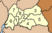
The district is divided into eight sub-districts (tambons), which are further subdivided into 65 villages (mubans). Yan Ta Khao is a township (thesaban tambon) which covers parts of tambon Yan Ta Khao. There are further eight tambon administrative organizations (TAO).
| No.
|
Name
|
Thai name
|
Villages
|
Pop.
|
| 1. |
Yan Ta Khao |
ย่านตาขาว |
5 |
10,924 |
|
| 2. |
Nong Bo |
หนองบ่อ |
6 |
4,628 |
|
| 3. |
Na Chum Het |
นาชุมเห็ด |
9 |
8,179 |
|
| 4. |
Nai Khuan |
ในควน |
9 |
8,551 |
|
| 5. |
Phrong Chorakhe |
โพรงจระเข้ |
7 |
6,048 |
|
| 6. |
Thung Krabue |
ทุ่งกระบือ |
9 |
7,878 |
|
| 7. |
Thung Khai |
ทุ่งค่าย |
10 |
8,677 |
|
| 8. |
Ko Pia |
เกาะเปียะ |
10 |
6,531 |
|
|
|

