This airticle disnae cite ony references or soorces. Please help impruive this airticle bi eikin citations tae trustie soorces. Unsoorced material mey be challenged an remuived.
Hirakata 枚方 | |
|---|---|
Special ceety | |
| 枚方市 · Hirakata | |
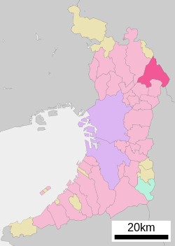
 Location of Hirakata in Osaka | |
| Coordinates: 34°49′N 135°39′E / 34.817°N 135.650°ECoordinates: 34°49′N 135°39′E / 34.817°N 135.650°E | |
| Kintra | Japan |
| Region | Kansai |
| Prefectur | Osaka |
| Govrenment | |
| • Mayor | Hiroshi Nakatsuka |
| Area | |
| • Total | 65.08 km2 (25.13 sq mi) |
| Population (August 1, 2011) | |
| • Total | 407,465 |
| • Density | 6260/km2 (16,200/sq mi) |
| Symbols | |
| • Tree | Willow |
| • Flouer | Chrysanthemum |
| • Bird | Common Kingfisher |
| Time zone | UTC+9 (Japan Staundart Time) |
| City Hall Address | 2-1-20 Ogaito-chō, Hirakata-shi, Osaka-fu 573-8666 |
| Website | Offeecial wabsteid |
Hirakata (枚方市 Hirakata-shi) is a ceety in north-eastren Osaka Prefectur, Japan, near the prefectural borders o Nara an Kyoto. It is renouned for its chrysanthemum doll exhibition, as well as Hirakata Park — an amusement pairk featurin five roller coasters.
The ceety wis foondit on 1 August 1947. On 1 Aprile 2001, Hirakata wis designatit as a special ceety o Japan.
The tot aurie o the ceety is 65.07 km². As o 1 Januar 2010, the ceety haes an estimatit population o 411,777, an a population densitie o 6,327.24 bodies per km².

