Town in New York, United States
Morristown |
|---|
|
| Town of Morristown |
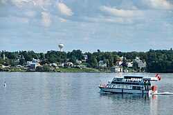 Morristown as seen across the St. Lawrence River |
| Country | United States |
|---|
| State | New York |
|---|
| County | St. Lawrence |
|---|
| Settled | Circa 1808 |
|---|
| Established | 1821 |
|---|
| Named for | Gouverneur Morris |
|---|
|
| • Total | 59.4 sq mi (154 km2) |
|---|
| • Land | 45.9 sq mi (119 km2) |
|---|
| • Water | 13.6 sq mi (35 km2) |
|---|
|
| • Total | 1,974 |
|---|
| Time zone | UTC-5 (Eastern (EST)) |
|---|
| • Summer (DST) | UTC-4 (EDT) |
|---|
| ZIP code | 13664 |
|---|
| Area code | 315 |
|---|
| FIPS code | 36-012-48543 |
|---|
| GNIS feature ID | 0979194 |
|---|
Morristown is a town in St. Lawrence County, New York, United States. The population was 1,974 at the 2010 census. The town is named after Gouverneur Morris, a signer of the United States Declaration of Independence and landowner in New York.
The Town of Morristown is on the northwestern part of the county and contains a village also named Morristown. The village and town are northwest of Gouverneur.
History
The town, part of Macomb's Purchase, was first settled permanently circa 1808 on the site of the present hamlet (and former village) of Morristown.
One of the first battles in the War of 1812 was a naval battle in the St. Lawrence River between two warships.
The town was established in 1821 from part of the Town of Oswegatchie, where it was known as "Haque.". Morristown was reduced twice to make new towns: Hammond (1827) and Macomb (1841).
Due to the lack of waterpower, a windmill was erected in 1828, but stopped working and was abandoned two years later.[1]
Geography
According to the United States Census Bureau, the town has a total area of 59.4 sq mi (154 km2), of which 45.9 sq mi (119 km2) is land and 13.6 sq mi (35 km2) (22.83%) is water.
The northern town line of Morristown is the international border with Ontario, Canada, defined by the St. Lawrence River. The town is dominated by two major bodies of water: the St. Lawrence River and Black Lake, which defines the southern town line.
New York State Route 37 is an east–west highway. New York State Route 12, another east–west route, is more northerly and follows the St. Lawrence River. New York State Route 58 is a north–south route, which intersects NY-37 at the hamlet of Morristown.
Demographics
Historical population
| Census | Pop. | Note | %± |
|---|
| 1820 | 827 | | — |
|---|
| 1830 | 1,618 | | 95.6% |
|---|
| 1840 | 2,809 | | 73.6% |
|---|
| 1850 | 2,274 | | −19.0% |
|---|
| 1860 | 2,284 | | 0.4% |
|---|
| 1870 | 1,954 | | −14.4% |
|---|
| 1880 | 2,186 | | 11.9% |
|---|
| 1890 | 1,966 | | −10.1% |
|---|
| 1900 | 1,798 | | −8.5% |
|---|
| 1910 | 1,888 | | 5.0% |
|---|
| 1920 | 1,719 | | −9.0% |
|---|
| 1930 | 1,658 | | −3.5% |
|---|
| 1940 | 1,635 | | −1.4% |
|---|
| 1950 | 1,569 | | −4.0% |
|---|
| 1960 | 1,776 | | 13.2% |
|---|
| 1970 | 1,823 | | 2.6% |
|---|
| 1980 | 1,921 | | 5.4% |
|---|
| 1990 | 2,019 | | 5.1% |
|---|
| 2000 | 2,050 | | 1.5% |
|---|
| 2010 | 1,974 | | −3.7% |
|---|
| 2016 (est.) | 1,913 | [2] | −3.1% |
|---|
|
As of the census[4] of 2000, there were 2,050 people, 816 households, and 581 families residing in the town. The population density was 44.7 inhabitants per square mile (17.3/km2). There were 1,535 housing units at an average density of 33.5 per square mile (12.9/km2). The racial makeup of the town was 97.56% White, 0.49% Black or African American, 0.98% Native American, 0.10% Asian, 0.20% from other races, and 0.68% from two or more races. Hispanic or Latino of any race were 1.02% of the population.
There were 816 households, out of which 29.9% had children under the age of 18 living with them, 56.4% were married couples living together, 10.2% had a female householder with no husband present, and 28.7% were non-families. 23.9% of all households were made up of individuals, and 8.8% had someone living alone who was 65 years of age or older. The average household size was 2.50 and the average family size was 2.90.
In the town, the population was spread out, with 25.0% under the age of 18, 6.0% from 18 to 24, 26.7% from 25 to 44, 28.3% from 45 to 64, and 13.9% who were 65 years of age or older. The median age was 40 years. For every 100 females, there were 99.2 males. For every 100 females age 18 and over, there were 98.3 males.
The median income for a household in the town was $33,458, and the median income for a family was $36,591. Males had a median income of $30,474 versus $20,741 for females. The per capita income for the town was $17,133. About 11.5% of families and 16.4% of the population were below the poverty line, including 26.7% of those under age 18 and 5.9% of those age 65 or over.

